


|
||

|

|
|

|
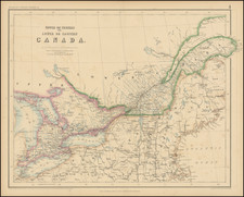
Canada of Niew Vrankryk, engraved by Anthoine de Winter and published in Utrecht in 1683 by Joannes Ribbius, captures an invaluable representation of Canada and the Great Lakes region at the end of the 17th century. Adapted from the pioneering cartography of Nicolas Sanson, this map is a successor to Sanson's larger 1656 map, presenting several crucial updates and distinctions in geography and regional nomenclature.
The late 17th century was marked by an intensified European interest in the North American territories, catalyzed by the intersections of colonial aspirations, commercial interests, and religious missions. Both the French and English were vying for influence in these regions, resulting in a complex web of claims, explorations, and settlements. This map showcases a variety of first-time inclusions and noteworthy alterations. Notably, it introduces "Lake Erie ou du chat," an allusion to the native inhabitants described with panther-like characteristics. Further improvements are discernible in the depiction of the drainage systems around the Great Lakes and St. Lawrence, a testament to the increased geographical knowledge stemming from Jesuit explorations and French fur traders.
The nuances in this map offer a layered narrative. A more detailed representation of Hudson Bay surpasses previous cartographic iterations, while geographical shifts like the introduction of Long Island, the correct placement of New Amsterdam, and the refined trajectory of the Delaware River all signal an evolving understanding of the territory. The mention of the Swedish Colony, although already subdued by this time, along with the portrayal of New Netherlands extending to Cape Cod, captures the colonial aspirations and territorial disputes of the age.
Ribbius's collaboration with Anthoine de Winter, culminating in this map, draws heavily from Nicolas Sanson's 1657 map published in Paris. Sanson's influence is clear, especially in the signature depiction of the open Great Lakes. However, while the cartography borrows from Sanson, the geopolitical nuances differ. The continued Dutch claims to the New Netherlands and the omission of the English presence in Carolina stand as stark reminders of contested territories and evolving colonial landscapes during this period.
States
- State 1: No graticule or grid of longitude and latitude (1683)
- State 2: A graticule added. A number of mountain ranges are inserted, particularly in Canada. French claims in Carolina indicated. (1699)
- State 3: The title altered to CANADA/ of/ NIEW VRANKRYK... (1705)
- State 4: Title reverts verbatim to the earlier French one with minor differences: no punctuation between nationalities in fourth line. (1734)
- State 5: The plate number 260 engraved top right. (circa 1738)
Nicholas Sanson (1600-1667) is considered the father of French cartography in its golden age from the mid-seventeenth century to the mid-eighteenth. Over the course of his career he produced over 300 maps; they are known for their clean style and extensive research. Sanson was largely responsible for beginning the shift of cartographic production and excellence from Amsterdam to Paris in the later-seventeenth century.
Sanson was born in Abbeville in Picardy. He made his first map at age twenty, a wall map of ancient Gaul. Upon moving to Paris, he gained the attention of Cardinal Richelieu, who made an introduction of Sanson to King Louis XIII. This led to Sanson's tutoring of the king and the granting of the title ingenieur-geographe du roi.
His success can be chalked up to his geographic and research skills, but also to his partnership with Pierre Mariette. Early in his career, Sanson worked primarily with the publisher Melchior Tavernier. Mariette purchased Tavernier’s business in 1644. Sanson worked with Mariette until 1657, when the latter died. Mariette’s son, also Pierre, helped to publish the Cartes générales de toutes les parties du monde (1658), Sanson' atlas and the first French world atlas.
![[ British Colonies in North America ] Carte Nouvelle de L'Amerique Angloise contenant tout ce que les Anglois possedent sur le Continent de L'Amerique Septentrionale . . .](https://storage.googleapis.com/raremaps/img/small/100143.jpg)
![[ Canada / New France Official Report Regarding Return of Fort Bourbon and Dispute with Hudson Bay Company ] May 27, 1699 Report of Louis II Phélypeaux, Comte de Pontchartrain](https://storage.googleapis.com/raremaps/img/small/100562.jpg)
![Carte Reduite Des Costes Orientales De L'Amerique Septentrionale . . . contenant L'Isle Royale . . . La Nouvelle Angleterre et la Nouvelle Yorc . . . MDCCLVII [with Plan of Boston Harbor] Plan du Havre de Baston](https://storage.googleapis.com/raremaps/img/small/80006.jpg)
