|
||

|

|
|

|
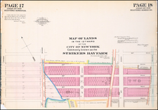
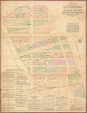
The First Comprehensive Historical Mapping of Manhattan Docks & Wharves
A large and very rare wall map of Manhattan south of 51st Street, encompassing all the existing and available historical features of Manhattan's waterfront, dating back nearly 200 years.
This remarkable map meticulously compiles details along the New York City Waterfront, including contemporary ownership information and historical ownership data dating back as far as the 17th Century.
In 1873, the New York City Department of Docks commissioned a significant cartographic project under the supervision of Charles K. Graham, culminating in a seven-foot-tall map that traces the development of Manhattan's waterfront from the Battery to Fifty-first Street. This map synthesizes over two centuries of geographic and urban change, charting the transformation of the shoreline from 1686 to the late 19th century.
The map serves as a historical ledger, detailing the original city grants of lands under water made to various parties and the subsequent alterations to the waterfront, including the establishment of pier and bulkhead lines from 1750 to the date of the map's creation in 1873. This meticulous record follows pivotal moments in New York City’s development, such as the report of the Wharves Committee of the Board of Aldermen in 1836 and the significant legislative actions in 1855 and 1856 that shaped the city’s approach to maritime infrastructure, and ultimately, the creation of the Department of Docks in 1870.
The historical necessity for the map's creation was a response to a series of legislative and administrative developments concerning New York’s waterfront, a process that began as early as 1855 with the formation of the Harbor Commission. This body's efforts, alongside those of the Wharves Committee and the subsequent Sinking Fund Commission reports of 1868, illustrate the increasing sophistication and centralization of waterfront management that preceded the map's production.
The culmination of these efforts was the founding of the Department of Docks in 1870, a pivotal event that signified a paradigm shift in the city's handling of its waterfront. By 1872, the Department was producing maps and the following year, this monumental 16 sheet map became its first comprehensive work.
The map is the largest scale single map of New York City published in the 19th Century, dwarfing even the remarkable Galt & Hoy map of 1879 in scale and grandeur.
Rarity
The map is extremely rare. We note only 1 complete example of the map offered for sale auction in the past 100 years, as well as 2 examples offered in dealer catalogues Merwin Sales Company in 1911 and High Ridge Books in 1999 (with extensive loss).
OCLC locates 3 examples (Cornell, Princeton and New York State Historical Society). We also note examples in the New York Public Library.

![[ Central Park ]](https://storage.googleapis.com/raremaps/img/small/75716.jpg)