|
||

|

|
|

|
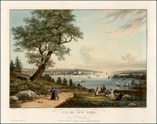
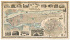
The Best Map of New York City Ever Made.
A superlative example of Will L. Taylor's monumental view-map The City of New York. Taylor's view of Manhattan is the greatest American bird's-eye view ever made as well as the greatest map of the City of New York. This is the fourth known example (the only one not in an institution), and it is in by far the best condition of all extant examples.
The view covers Manhattan from its southern tip up to Spuyten Duyvil and Westchester beyond. The adjacent shores of Brooklyn, Queens, the Bronx, and New Jersey are also illustrated. The massive scale of the map (it is over 6.5-feet tall) allows for unprecedented detail, with every building on the map rendered individually. The exceptional visual resolution of the map is augmented with long keys at the left and right. On the right, the key lists: U.S. Buildings and Offices; City and County Buildings; Offices and Departments; Station Houses; Charities and Correction Department; Civil and Criminal Courts; Districts Courts; Police Courts; U.S. Courts; General Shipping (with a separate numbering system for the wharves and piers); Ferries-North River; [Ferries] East River; Markets; Exchanges; Newspapers-Daily; Hospitals; Seminaries and Colleges; Libraries; Military-National; Military-State; Theatres, Halls, etc.; City Schools (Grammar and Primary); and Asylums and Homes.
The map was partially funded with advertising for local businesses, and so a series of inset "cards" illustrate the headquarters or products of some of the foremost businesses of the day.
The Taylor map surpasses the other potential claimant for the best map of New York, Bernard Ratzer's Plan of the City of New York..., in numerous respects; it is rarer (perhaps by a factor of 10x), it is larger (almost twice as large), and has wider coverage and more detailed coverage, extending as it does over the entire island of Manhattan.
In Manhattan in Maps, Cohen & Augustyn have the following comment about the historical context in which the map was produced:
The Brooklyn Bridge was nearing completion in 1879 when William I. (sic) Taylor drafted his spectacular bird's-eye view of New York City. Unlike any other map fo the city, this one includes practically every building on Manhattan Island. It was executed at a critical time in New York's history as many of the distinctive elements that gave the city its "titanic energy and force" were in place. Central Park had been completed in 1876; the first skyscrapers had been erected; and elevated trains were in operation.
The view was published by Galt & Hoy "Publishers, Designers, Lithographers & Engravers, Views of Cities and Summer Resorts a Specialty" in New York in 1879.
Galt & Hoy
According to Reps, Views and Viewmakers, J.L. Galt & Co. published three bird's-eye views of Massachusetts towns in 1878, all listing the office address of 111 Liberty Street. We find an additional view published by J.L. Galt, depicting Hartford, Connecticut, was issued in 1877. Sometime in 1878, the firm was reconstituted as Galt & Hoy, with Henry E. Hoy, a member of a prominent and wealthy family, joining as a partner. This marked a change in the company's focus away from Massachusetts and towards New York and other locations. One of the first views by the newly-formed firm was an 1878 bird's-eye of Newport, Rhode Island, where Hoy liked to summer. Tragically, Hoy found the view making business extremely difficult, and in December of 1878, he became overwhelmed by the large capital outlays and paltry revenue of the company. On December 17, Hoy met with his brother at his offices on Liberty Street and informed him of the financial difficulties that the firm faced. Shortly thereafter he shot himself. The New York Times coverage of the incident draws attention to the difficulties faced by view-makers in the 1870s, even during that relative boom-time in that industry:
"About his business," he continued, "I know little. For the last year he has been engaged with his partner in a comparatively new scheme. They have had men employed taking perspective views of different portions of the largest cities in the United States. These publications were intended to assist business men. It required a very large outlay of capital to carry on the scene, and as yet the business had not returned the money. Mr. Galt is now in the West attending the business."
It seems that Hoy had been brought in to fund the production of views, but that the business was not returning his money quickly enough (or, perhaps, at all). The firm continued to publish into 1879, perhaps exhausting the last of the work that Hoy's money had financed, before going defunct and disappearing from the historical record. This tragic story probably explains why the present view is so exceptionally rare today: there simply was not enough money left in the firm to support large-scale printing and distribution.
Will L. Taylor, the genius artist responsible for the image merits only one entry in Reps, for the present view.
Rarity
The view is extremely rare. There is a copy in black and white at the Library of Congress (perhaps the publisher intended to save money on the deposit copy, not printing the other two stones and hand-finishing), New York Public Library (varnished, in sheets, with substantial damage and loss), and the New-York Historical Society (not illustrated, but described as in two "fragments). The map also traded twice in the early-1990s, though, tragically, one of these examples was destroyed in the September 11th Attacks. There is a tragic irony to this, as the office of Galt & Hoy, between Church Street and Greenwich on Liberty, was on the same plot as the old 4 World Trade Center, which was destroyed in the attack. The Galt & Hoy office is illustrated and labeled on this map.
Thus, this is only the fourth known copy, and it is by far the best in terms of both condition and color.
Stokes (Volume III, pages 776-777) comments about the later (circa 1900) printing:
The map was reprinted by Peter W. Gillin, about 1900, with many alterations, having been brought up to date by the addition of new buildings, etc., but still showing many old landmarks which in reality had long since disappeared. The N.Y. Public Library owns the only known copy of this state, which lacks the advertisements in the blank spaces. In this form the plate seems never to have been put on the market.
This remarkable map--a monument of patience and skill--shows, in considerable detail, practically every building on Manhattan Island. It was evidently issued primarily as an advertising medium. In addition to the numerous "cards" printed upon it, the map contains a list of the leading hotels, schools, courts, theatres, and public buildings, as well as the piers, ferries, etc.
The west side of the island above 59th Street appears in its undeveloped state. On the opposite shore of New Jersey may be seen the Elysian Fields, at Hoboken, for many years a favorite resort of New Yorkers.