|
||

|

|
|

|
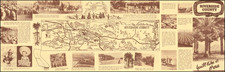
California's Highway Road Map of 1930: A Window into Motor Tourism
The 1930s was an era of transformation and expansion in the United States, particularly in the West and, most notably, in California. This highway road map of California from about 1930 by the Mid-West Map Company not only serves as a geographical guide but also encapsulates a period in American history marked by the growth of highways and the burgeoning enthusiasm for motor tourism.
After World War I, America witnessed an automotive boom. Cars were no longer just for the elite; they became more accessible to the general populace. This democratization of mobility fueled the development of a vast network of highways, especially in vast states like California. These highways, as seen on the map, became the arteries of travel, commerce, and leisure.
California, with its diverse landscape ranging from sun-kissed beaches to towering mountain ranges, emerged as a hotspot for motor tourism. This travel trend was reflected in the meticulously detailed map. The inclusion of route and surface designations, mile markers, and other vital travel information made it an indispensable companion for the discerning traveler. Equally significant were the indications of airports, campsites, and rail lines, showcasing the multifaceted nature of transportation and leisure in the state.
However, more than just routes and landmarks, the map highlighted the commercial and service aspects of road travel. The detailed notes on places for meals, additional information, and essential services transformed the map from a mere navigation tool to a comprehensive travel guide. The advertisements scattered on the map and its verso attest to the commercial opportunities businesses saw in catering to the needs of motorists.
The insets providing transportation details of the Bay Area present a fascinating snapshot of a region in transition. The absence of the Bay and Golden Gate bridges, iconic symbols of the state today, is keenly felt. Their mention as being under construction and the consequent emphasis on ferry services underscores a brief period when water transport took precedence in the area. The ferry operators, seizing this temporary advantage, not only facilitated transportation but also offered tourists the unique experience of witnessing the birth of these iconic structures.
The highways and the emerging culture of motor tourism between the two World Wars represented a significant shift in the American lifestyle. It was a period of discovery, adventure, and an embrace of the open road. This highway map, in all its detail and commercial annotations, symbolizes not just the roads of California, but the spirit of an age where the journey became just as important as the destination.
![[Imperial & Coachella Valley Advertising Map -- Valerie Jean Date Shop]](https://storage.googleapis.com/raremaps/img/small/69651.jpg)