|
||

|

|
|

|
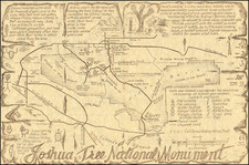
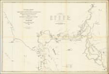
The Earliest Privately Surveyed Navigational Chart of the California Gold Rush Era -- Surveyed By William Tecumseh Sherman
Rare and very early navigational chart of Suisun Bay from Carquinez Strait to the confluence of the Sacramento and San Joaquin Rivers, commissioned by the promoters of the recently laid out town of New York, which at the time was being promoted as a the future capital of California in 1849.
At the time of its creation, it became the most accurate and reliable navigational chart for the many sailing ships plying the waters between San Francisco and the Sacramento River, the gateway to the Gold Diggings.
The town of New York would for the next few years become a primary shipping hub between San Francisco and the Gold Regions. At the time of the chart's publication, Suisun Bay was the primary route of commerce between San Francisco and the Gold Regions, with the location of the town of New York at a focal point of commercial transit.
The chart is noteworthy for at least two reasons. In addition to being one of the earliest surviving examples of a map intended to promote the sale of real estate in California, it is quite likely the earliest surviving example of a navigational chart of any portion of California's internal waterways created from a privately commissioned nautical survey.
As noted, the map was "Surveyed for Col. J.D. Stevenson, Geo. McDougal, Wm. C. Parker and Saml. Norris, proprietors of the projected City of New York of the Pacific." Signed beneath the title by R.P. Hammond, William Tecumseh Sherman and James Blair.
The map was prepared for a group of New York real estate speculators, who were promoting New York as both commercial shipping hub and future capital of California. General William Tecumseh Sherman recounts his involvement in the creation of the chart in his Memoirs as follows:
R.P. Hammond, James Blair, and I made a contract to survey for Colonel J.D. Stevenson his newly-projected city of 'New York of the Pacific', situated at the mouth of a channel through Suisun Bay. We then sounded the bay back and forth, and staked out the best channel up Suisun Bay... We then made the preliminary surveys of the city of 'New York of the Pacific', all of which were duly plotted; and for this work we each received from Stevenson five hundred dollars and ten or fifteen lots. I sold enough lots to make up another five hundred dollars, and let the balance go . . .
In his description of the map, Warren Heckrotte identifies a number of references to the surveying and creation of this chart referenced in the Alta California newspaper in 1849:
May 1, 1849: Hammond, Sherman & Blair contracted for complete and perfect survey and buoying out of the channel, together with sailing directions. The survey has been made and a chart completed so perfectly marked and buoyed and the channel pointed out clearly. The chart will be sent to the U.S. by the first steamer to be lithographed and sufficient number of copies sent here to furnish one to each vessel in the bay.
June 20: Charts of the Bay of Suisun drawn from the survey made for the proprietor of New York of the Pacific may be had on application to E.H. Rowe Surveyor Parker House.
October 25: Messrs Stevenson Parker & Co. proprietors of New York of the Pacific have had lithographed a chart of Suisun Bay showing the soundings from Karquinez Strait to the site of their projected city from a survey made for them by Lieut. Blair & Hammond USN."
Heckrotte also notes that there was "A map of New York of the Pacific, prepared by Hammond, was also published in 1849. Reproduced in Reps, Cities of the American West, fig. 7.19."
New York of the Pacific
In 1849, the Rancho Los Medanos passed from the Mesa family, the original Spanish settlers, into the hands of Colonel J. D. Stevenson and Dr. William Parker. Colonel Stevenson had ambitious plans for the land, and engaged William Tecumseh Sherman to survey a townsite. Sherman accordingly surveyed, and plotted a town upon which Stevenson bestowed the name "New York of the Pacific."
The first settlers of the place were two brothers, Joseph H. and W. W. Smith, who, in July, 1849, proceeded with their families to the projected metropolis and built a structure which was called the "New York House." Other settlers arrived, and for a year or two "New York of the Pacific" was a thriving port.
Stevenson and Parker made an effort in December, 1849, to have "New York of the Pacific" made the capital of California They proposed to erect a capitol building, Governor's residence and other buildings at a cost of $100,000. The project failed, however, when Vallejo was chosen in 1850 as California's new capital city. The ownership of the Los Medanos Rancho thereafter passed through several hands. Pioche and Bayerque, two French bankers, succeeded Stevenson and Parker in ownership of the land.
At the time, commerce between San Francisco and the river towns was handled by sailing craft, many of which called at New York for provisions. Steamboats, however, soon supplanted the slower sailing vessels, and with their advent, "New York of the Pacific" rapidly declined. In the course of time, its name was changed to New York Landing. The famous Black Diamond vein of coal was discovered at Nortonville, six miles to the south, in 1859, and soon afterwards a railroad was built from the mines to New York. For many years it was the shipping point for the coal from the Black Diamond mine, and ultimately it dropped its original name and became known as Black Diamond.
The map brings together a number of important American figures:
William Tecumsey Sherman (1820-1891) was an American soldier, businessman, educator, and author. He served as a general in the Union Army during the American Civil War (1861-65). While best known for his involvement in the American Civil War, he was an early participant in California's history.
While many of his colleagues saw action in the Mexican-American War, Sherman performed administrative duties in the captured territory of California. Along with fellow Lieutenants Henry Halleck and Edward Ord, Sherman embarked from New York on the 198-day journey around Cape Horn aboard the converted sloop USS Lexington. Sherman and Ord reached the town of Yerba Buena, in California, two days before its name was changed to San Francisco. In 1848, Sherman accompanied the military governor of California, Col. Richard Barnes Mason, in the inspection that officially confirmed that gold had been discovered in the region, thus inaugurating the California Gold Rush. Sherman, along with Ord, assisted in surveys for the sub-divisions of the town that would become Sacramento.
In 1853, Sherman resigned his captaincy and became manager of the San Francisco branch of the St. Louis-based bank, Lucas, Turner & Co. He returned to San Francisco at a time of great turmoil in the West. He survived two shipwrecks and floated through the Golden Gate on the overturned hull of a foundering lumber schooner. Sherman suffered from stress-related asthma because of the city's aggressive business culture. Late in life, regarding his time in a San Francisco experiencing a frenzy of real estate speculation, Sherman recalled: "I can handle a hundred thousand men in battle, and take the City of the Sun, but am afraid to manage a lot in the swamp of San Francisco." In 1856, during the vigilante period, he served briefly as a major general of the California militia.
Sherman's San Francisco branch closed in May 1857, and he relocated to New York on behalf of the same bank. When the bank failed during the financial Panic of 1857, he closed the New York branch. In early 1858, he returned to California to wrap-up the bank's affairs there, his last contact with California before the Civil War.
Jonathan Drake Stevenson (1800-1894) was the commanding officer of the First Regiment of New York Volunteers during the Mexican-American War in California. In 1846, President Polk offered Stevenson the command of a regiment of volunteers to be raised as part of the American occupation army during the Mexican-American War in California. Colonel Stevenson raised a volunteer regiment of 770 men to go to California. Stevenson with his Regiment sailed around Cape Horn for California on September 26, 1846, and arrived at San Francisco March 7, 1847. After his arrival in San Francisco, Stevenson joined General Stephen W. Kearny at Monterey and was made commander of the post. In May, 1847, he became the military commander of the southern district of California with headquarters in Los Angeles.
When his Regiment was mustered out of service in 1848, Stevenson went to the mining community of Mokelumne Hill. He was appointed alcalde of the settlement, and drew up a code of mining laws and regulations. He returned to San Francisco to enter the real estate business with Dr. William C. Parker, who had been assistant surgeon in the Regiment of New York Volunteers. He bought the southern half of Rancho Los Medanos in 1849 and laid out a site for a town they called "New York of the Pacific", which was changed to Pittsburg in 1911. He was appointed Shipping Commissioner for the Port of San Francisco in 1872.
Major Richard P. Hammond was active in California as early as 1849. In 1849, he conducted the resurvey of the City of Stockton. In 1851, he served as the California Speaker of the House of Representatives. In 1857 he served as the Port Collector for San Francisco and also served as the President of the San Francisco Police Commission Board. By 1878, he was the president of the California Pacific Railroad Company.
Lieutenant James Blair was active in California as early as 1848. He and R.P. Hammond were part of a commission appointed to select military sites in San Francisco Bay, which resulted in the selection of Mare Island Navy Yard and the selection of Benecia for the location of storehouses and arsenals for the Army.
Rarity
OCLC lists just one copy of the map, at the University of California Berkeley. The heavily damaged Heckrotte copy was sold at PBA Galleries in 2016. The present example was purchased on December 5, 2017 at Swann Galleries, Lot #26.