|
||

|

|
|

|
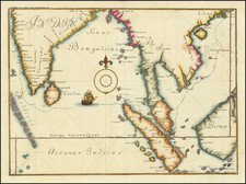
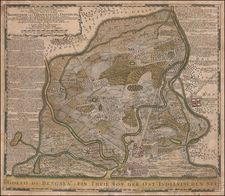
Sebastian Munster's 1540 map, Tabula Asiae XI, represents a rare early depiction of the Indian Ocean and contiguous regions, extending from Southeast Asia to the Ganges River and north to the Himalayas. Based on Ptolemaic geography and devoid of a passage to the Pacific, this map is a significant part of Munster's renowned work, Geographia, and showcases the cartographic conventions of the 16th century.
Munster's contributions to cartography in the 16th century were profound, not only in terms of technical mastery but also in the way he integrated classical geography with contemporary information. Geographia, first issued in 1540, was a landmark compilation that incorporated Ptolemaic maps alongside modern maps of the time. The inclusion of the first separate maps of the four continents and the earliest obtainable map of Scandinavia attests to the innovative nature of Munster's work. Tabula Asiae XI reflects this innovation and serves as a valuable window into both the geographical knowledge and misconceptions of the period.
The map's content, influenced by the writings of Ptolemy, reveals a blend of empirical observation and classical tradition. The inclusion of place names such as "Ciuitates Samba, Berabona, Be gynga, Perimula," along with the note "Habet hæc India tigres, gallos barbatos, psittacos albos &c." and the related woodcut illustration, reflects a curiosity and fascination with distant lands. These elements not only provide geographical details but also enrich the map with cultural and natural features, offering a multifaceted view of Southeast Asia and the surrounding areas.
Sebastian Munster's influence extended beyond cartography. As a linguist and mathematician, his scholarly pursuits added depth to his geographical works. His call for geographical information led to an influx of foreign material, some of which might not have been entirely accurate but provided a rich and nuanced cartographic picture. In the context of the intellectual environment of the 16th century, Tabula Asiae XI represents a synthesis of science, art, and exploration, epitomizing the spirit of Renaissance humanism and the quest for knowledge.
Sebastian Münster (1488-1552) was a cosmographer and professor of Hebrew who taught at Tübingen, Heidelberg, and Basel. He settled in the latter in 1529 and died there, of plague, in 1552. Münster made himself the center of a large network of scholars from whom he obtained geographic descriptions, maps, and directions.
As a young man, Münster joined the Franciscan order, in which he became a priest. He then studied geography at Tübingen, graduating in 1518. He moved to Basel, where he published a Hebrew grammar, one of the first books in Hebrew published in Germany. In 1521 Münster moved again, to Heidelberg, where he continued to publish Hebrew texts and the first German-produced books in Aramaic. After converting to Protestantism in 1529, he took over the chair of Hebrew at Basel, where he published his main Hebrew work, a two-volume Old Testament with a Latin translation.
Münster published his first known map, a map of Germany, in 1525. Three years later, he released a treatise on sundials. In 1540, he published Geographia universalis vetus et nova, an updated edition of Ptolemy’s Geographia. In addition to the Ptolemaic maps, Münster added 21 modern maps. One of Münster’s innovations was to include one map for each continent, a concept that would influence Ortelius and other early atlas makers. The Geographia was reprinted in 1542, 1545, and 1552.
He is best known for his Cosmographia universalis, first published in 1544 and released in at least 35 editions by 1628. It was the first German-language description of the world and contained 471 woodcuts and 26 maps over six volumes. Many of the maps were taken from the Geographia and modified over time. The Cosmographia was widely used in the sixteenth and seventeenth centuries. The text, woodcuts, and maps all influenced geographical thought for generations.