


|
||

|

|
|

|
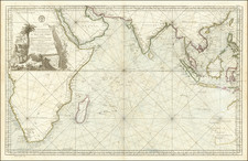
One of the most influential sea charts of India in the mid-18th century.
Striking antique map of India and surrounding islands, extending from the Bay of Bengal and the mouth of the Ganges to Gujarat, including a detailed treatment of Sri Lanka, the Maldives, and the Laccadive Islands. Much of the route of the Ganges is marked as unknown; the river's source at Gaumukh cave would not be recorded until 1818.
Jacques Nicolas Bellin was the chief hydrographer of the French Depot de la Marine for a significant period of time in the mid-18th century. Under his direction, the Depot de la Marine systematically mapped the coastlines of the world with more precision and accuracy than the contemporary English and Dutch chart makers of the time period.
Jacques-Nicolas Bellin (1703-1772) was among the most important mapmakers of the eighteenth century. In 1721, at only the age of 18, he was appointed Hydrographer to the French Navy. In August 1741, he became the first Ingénieur de la Marine of the Dépôt des cartes et plans de la Marine (the French Hydrographic Office) and was named Official Hydrographer of the French King.
During his term as Official Hydrographer, the Dépôt was the one of the most active centers for the production of sea charts and maps in Europe. Their output included a folio-format sea atlas of France, the Neptune Francois. He also produced a number of sea atlases of the world, including the Atlas Maritime and the Hydrographie Francaise. These gained fame and distinction all over Europe and were republished throughout the eighteenth and even in the nineteenth century.
Bellin also produced smaller format maps such as the 1764 Petit Atlas Maritime, containing 580 finely-detailed charts. He also contributed a number of maps for the 15-volume Histoire Generale des Voyages of Antoine François Prévost.
Bellin set a very high standard of workmanship and accuracy, cementing France's leading role in European cartography and geography during this period. Many of his maps were copied by other mapmakers across the continent.
![[ Indian Ocean - Sailing to Batavia ] Route Exacte De Gamron a Batavia et de Batavia a Gamron](https://storage.googleapis.com/raremaps/img/small/44380.jpg)
![[ Tibet / Nepal / Himalyas ] Carte von Tibet nach den neuesten Nachrichten entworfen 1790](https://storage.googleapis.com/raremaps/img/small/86165.jpg)