|
||

|

|
|

|
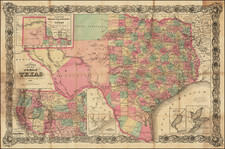
North America by the Society for the Diffusion of Useful Knowledge (SDUK), published in London in 1843, is a depiction of the continent at a pivotal juncture. The map strikingly delineates the Republic of Texas, which stands out in its vast size, independent from any neighboring territories.
The 1840s was a period of immense territorial shifts and political dynamics in North America. The decade bore witness to the Mexican-American War and the consequent Treaty of Guadalupe Hidalgo in 1848. The delineation of the Republic of Texas, which lasted from 1836 to 1845 before it was annexed to the United States, serves as a testament to the sovereignty it maintained for almost a decade. Its depiction, without any hint of New Mexico, offers a unique perspective on territorial boundaries before they took their more recognized forms.
This map enumerates major cities, rivers, mountains, and other geographical features, making it a valuable resource for understanding the physical terrain of the time. The presentation of "Upper California" in the interim between its independence from Mexico and the Gadsden Purchase underscores the volatile nature of borders and territories during this period. The absence of New Mexico, juxtaposed with the dominant presence of Texas, accentuates the historical context of regional disputes and geopolitical alignments.
Furthermore, the portrayal of distinct Western characteristics sheds light on the burgeoning westward expansion that would come to define the latter half of the 19th century. The map, both in its geographical representations and its hints at socio-political contexts, stands as an invaluable artifact from a transformative era in North American history.

![[ Indian Territory / North Texas / Arkansas ] General Topographical Map. Sheet XXIV. Plate CLIX](https://storage.googleapis.com/raremaps/img/small/95113.jpg)