|
||

|

|
|

|
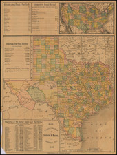
Detailed map of the the eastern part of Indian Territory, North Texas and western Arkansas.
The map primarily illustrates the roads, settlements, rivers, post offices and other details in the region, which extends southwest to the outskirts of Dallas, Texas. While a number of battles were fought in Arkansas, they were fought north and west of the region shown. Similarly, the battles fought in Texas were in different regions.
During the American Civil War, the regions of Indian Territory (present-day Oklahoma), North Texas, and western Arkansas were strategically significant and saw several skirmishes, battles, and troop movements. These areas were far removed from the primary theaters of war in the East, but their importance was underscored by their location, resources, and the loyalties of the Native American tribes.
Texas's role in the Civil War was primarily as a supplier of resources, particularly cattle. The state was mostly untouched by major battles, but North Texas was a region of concern due to its proximity to Union-controlled areas and its role in the supply chain.
Throughout the war, troop movements in these regions were primarily reactionary, responding to raids, securing supply lines, and maintaining or gaining control of strategic locations. By the end of the war, despite early Confederate successes, Union forces had made significant inroads into these regions, disrupting supply chains and gaining the support of several Native American tribes.
Atlas to Accompany the Official Records of the Union and Confederate Armies 1861-1865
The Atlas to Accompany the Official Records of the Union and Confederate Armies 1861-1865, published by the U.S. War Department, is a monumental cartographic record of the American Civil War, underscoring the strategic intricacies and operational complexities of the conflict. Lithographed by the renowned Julius Bien & Co. in New York between 1891 and 1895, this government publication provides an unparalleled visual companion to one of the most defining chapters in American history.
The end of the 19th century saw a renewed interest in documenting and understanding the Civil War, particularly from a military perspective. As veterans aged and the collective memory of the war began to fade, there was an emergent desire to preserve its history for future generations. It is within this context that the War Department undertook the massive project of compiling official records and accompanying them with detailed, accurate maps.
The atlas consists of 175 double-page sheets, predominantly focusing on battle plans and troop movements. The meticulous detailing in each plate gives insight into the tactical decisions and military maneuvers executed by both Union and Confederate forces. The sheer breadth of maps, covering numerous battles and campaigns, enables a comprehensive understanding of the war's geographical scope and the dynamic fluidity of frontlines over its duration.
Complementing these strategic visualizations, the atlas also includes a few sheets dedicated to the material culture of the war. Illustrations of uniforms, weapons, and flags not only provide a visual archive of the conflict's material aspects but also shed light on the distinct identities, technological advancements, and symbolic representations of both warring sides.
An outstanding feature of this atlas is its reliance on original sources from the period of the Civil War. Many of its plates are based on primary printed and manuscript maps produced during the conflict, ensuring an authenticity in representation. These original documents would have been created by military engineers, topographers, and cartographers who were directly involved in the planning and execution of campaigns. Their firsthand experience and immediate documentation provide a level of precision that later reconstructions might lack.
In summary, the Atlas to Accompany the Official Records of the Union and Confederate Armies 1861-1865 stands as a testament to the War Department's commitment to documenting the Civil War with unparalleled precision and detail. It not only serves as an indispensable resource for historians and military enthusiasts but also as a tribute to the countless soldiers who participated in this defining conflict. The combination of strategic maps with visual elements of material culture provides a holistic understanding of the war, capturing both its grand strategies and the personal experiences of those who fought in it.

![[Restricted] New Orleans (0-6)](https://storage.googleapis.com/raremaps/img/small/68648.jpg)