|
||

|

|
|

|
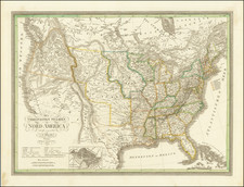
"Pioneers in the Introduction and Sale of Glidden Patent Steel Barb Fence Wire in the State of Texas"
Rare map and promotional pamphlet from Sanborn & Warner, illustrating their early efforts to promote and sell Glidden Patent Steel Barb Fence Wire in Texas. Produced by Washburn & Moen of Worcester, Massachusetts, the pamphlet includes a variety of contents typical of an almanac, such as calendar pages, population statistics, and standard weights and measures. It also provides detailed information on the Glidden barb wire, discussing its tensile strength options, guidelines for selection and usage, and pricing details.
The pictorial wrappers are adorned with images showing Glidden’s factory and a bale of barbed wire. The accompanying map, created by Rand, McNally & Co., bears the inscription "Compliments of Sanborn & Warner, Houston, Texas" and is supplemented with a smaller map of the US various informational lists, such as altitudes along the Texas & Pacific Railway, comparative annual rainfall data for select cities, and on the reverse side, a railway station and distance table, as well as other information.
The First Annual Compendium was published by Jone & Givens of Sacramento in 1883 and did not include a map. The first Houston edition was published in late 1884 for Sanborn & Warner, and printed by Clarke & Courts, and was entitled 1885 Glidden barb wire pocket compendium: containing valuable information in reference to fence building.
A later state (Fifth Annual) is recorded, with a different map of Texas.
Rarity
The pamphlet and map are extremely rare. The present example is earlier than any recorded example.
OCLC locates 2 examples of the 1884 edition (Amarillo Public Library and UT Austin) and 2 examples of the 1889 (Newberry Library and Texas Tech University). Yale records a 1950 reprint of this Third Annual 1887 edition.
We also note an example of the 1883 First Annual Compendium in the Floyd Hal Higgins Collection at UC Davis.
The Huntington Library holds a remarkable full color broadside for Glidden's Barbed Wire.
Rand McNally & Co. is a large American map and navigation company best known for its annual atlases. The company got its start in 1856, when William Rand opened a print shop in Chicago. He was joined in 1858 by a new employee, Andrew McNally. Together, the men established their namesake company in 1868. Originally, the company was intended to print the tickets and timetables for the trains running to and through Chicago; their first railway guide was published in 1869.
By 1870, they had shifted from just printing to publishing directories, travel guides, and newspapers. Their first map appeared in 1872 in a railway guide. The map was produced using a new wax engraving method, a cheaper process that gave the company an edge.
By 1880 Rand McNally had entered the education market with globes, wall maps, and geography texts for students. In 1923, Rand McNally published the first Goode’s World Atlas, named after its editor, Dr. J. Paul Goode. For generations afterward, this would be the standard classroom atlas.
In 1899, William Rand left the company, but McNally and his family remained, controlling the company for over a century. In 1904, they published their first road map intended for automobiles and by 1907 were publishing Photo-Auto Guides, which combined photography and mapping to help drivers. In 1924, they produced the Auto Chum, a precursor to their famous road atlases. Rand McNally would remain the leader in road maps and atlases throughout the twentieth century.
In 1937, Rand McNally opened its first store in New York City. Ever on the frontier of technology, Rand McNally pioneered the scribing process for printing tickets in 1958 and printed their first full-color road atlas in 1960. Arthur Robinson developed his now-famous projection of Rand McNally in 1969. By the 1980s, the company was exploring digital reproduction and digital databases of maps for truckers. In the 1990s, they lead the charge to develop trip-planning software and websites. Today, most of its products are available online or in a digital format, including maps for tablets and phones.

![[ Upper California, Texas and Mexico ] Carte Generale Du Mexique Ed Des Provinces-unies De L'Amerique Central ou Guatemala](https://storage.googleapis.com/raremaps/img/small/81604.jpg)