


|
||

|

|
|

|
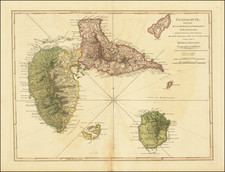
St. Christophers, or St. Kitts, surveyed by Anthony Ravell, Surveyor General of the islands of St. Christophers, Nevis, and Montserrat, presents an intricate cartographic picture of the island of St. Kitts. Published by Thomas Jefferys in London in 1775, the map stands as an exceptional example of 18th-century British cartographic artistry. An inset map in the upper right corner, also by Jefferys, portrays the island of Nevis, providing a broader geographical context.
The map's exhaustive detail, both topographical and man-made, provides a nuanced view of the islands. Various aspects, such as parishes, quarters, notable landmarks like the Londonderry Fort, Irish Town, and St. George's Church, are depicted, offering insights into the organization and social geography of the time. A unique feature of the map is its depiction of the Mount Misery, identified as a former volcano, with a noted height of 3,711 feet.
In addition, the map's 'Observations' provide an empirical sense of the islands' geographical aspects and human activity. Notably, it mentions the islands' size—68 square miles and nearly 44,000 acres of plantations—revealing the islands' significant engagement with agricultural endeavors, likely in sugar cultivation. Numerical figures marking the depth of the sea in fathoms provide an understanding of the marine geography around the islands.
St. Christophers, or St. Kitts by Anthony Ravell and Thomas Jefferys provides a meticulous record of these Caribbean islands' landscapes in the late 18th century. Its detail and precision offer insights into the islands' topography, societal structures, and economic activity, thereby providing a multifaceted understanding of the region during a key historical period.
Thomas Jefferys (ca. 1719-1771) was a prolific map publisher, engraver, and cartographer based in London. His father was a cutler, but Jefferys was apprenticed to Emanuel Bowen, a prominent mapmaker and engraver. He was made free of the Merchant Taylors’ Company in 1744, although two earlier maps bearing his name have been identified.
Jefferys had several collaborators and partners throughout his career. His first atlas, The Small English Atlas, was published with Thomas Kitchin in 1748-9. Later, he worked with Robert Sayer on A General Topography of North America (1768); Sayer also published posthumous collections with Jefferys' contributions including The American Atlas, The North-American Pilot, and The West-India Atlas.
Jefferys was the Geographer to Frederick Prince of Wales and, from 1760, to King George III. Thanks especially to opportunities offered by the Seven Years' War, he is best known today for his maps of North America, and for his central place in the map trade—he not only sold maps commercially, but also imported the latest materials and had ties to several government bodies for whom he produced materials.
Upon his death in 1771, his workshop passed to his partner, William Faden, and his son, Thomas Jr. However, Jefferys had gone bankrupt in 1766 and some of his plates were bought by Robert Sayer (see above). Sayer, who had partnered in the past with Philip Overton (d. 1751), specialized in (re)publishing maps. In 1770, he partnered with John Bennett and many Jefferys maps were republished by the duo.
![Carta General de las Islas Antillas Menores [North sheet]](https://storage.googleapis.com/raremaps/img/small/93244.jpg)
![[ Virgin Islands ] Anguilla to Porto Rico Shewing the Approaches to the Virgin Islands](https://storage.googleapis.com/raremaps/img/small/86323.jpg)