


|
||

|

|
|

|
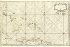
Northern Sheet of the Rare Lopez 2-sheet Map of the Lesser Antilles
Tomas Lopez's map of the Lesser Antilles Islands, entitled "Carta General de las Islas Antillas Menores," published in Madrid in 1781, is an exquisite example of late 18th-century cartography, capturing the geography of the Caribbean archipelago during that era.
The map encompasses an expansive territory, extending from Anguilla, St. Martin, and San Bartolome (St. Barths) in the north, down to Martinique, Marie Galante, and the northern part of Dominica in the south. The map includes rhumb lines, a network of lines crossing at right angles that allowed navigators to plot their courses more straightforwardly. The map also takes note of significant marine features such as shoals and depths.
Perhaps most remarkable is Lopez's extensive commentary on the mapping (or lack thereof) for the region. The text at the right translates as follows:
Although there are astronomical observations to determine the longitude and latitude of some Antilles Islands, geographers cannot accurately place them all as required for safe and precise navigation. Those who are familiar with the utility of maps and use them for navigation have long been awaiting astronomical observations of the islands where they have not been made. This hope is founded on the belief that the powers that possess these islands are not only wise but also generous, sharing their discoveries for the common benefit. In the limited space presented here, I will explain what can be said about the construction of this map.
The longitudes and latitudes of various points in Martinique have been distinctly marked by Mr. Bellin in his map of the Gulf of Mexico from the year 1749, in the map of the Antilles from 1758, in the map of Martinique from the same year, and in the map of the Western Ocean from 1766. It is quite peculiar that there is such inconsistency in the works of a single author, which would not be so if he explained the principles from which they originated, as we know that geographical perfection lies in novelty and accuracy. I adopted the latitude and longitude marked on the map because it is the closest to that of Father [Louis Éconches ] Feuille.
The outline and shape of the island of St. Lucia are taken from the one published in English in the year 1775 by the geographer Thomas Jefferys, which is the most accurate. The island of St. Vincent was translated from the English map surveyed in the year 1773 after the treaty concluded between the English and the Caribs.
The size of the island of Barbados is not consistent among the same English authors, but the one by the geographer Manuel Bowen was preferred over all others. For the island of Grenada, the accurate plan made by its governor, St. George Scott, in the year 1763 was taken into account.
There are many islets of different sizes between the islands of St. Vincent and Grenada, but their details are inaccurately represented in all maps, and sailors should exercise caution in this area.
The valuable public documents of the island of Tobago are credited to the English. The island of Dominica is accurately depicted based on a large-scale map created by John Byres in 1776.
The shape and placement of Marie-Galante Island were determined based on Mr. Bellin's chart, as well as the small islands of Les Saintes. The island of Guadeloupe, depicted in Mr. Bellin's map from 1758, does not have consistent latitude coordinates with those indicated in the Gulf of Mexico chart, the Antilles chart, or the Western Ocean chart. Father Ricciolo, and the Louis de Jaucourt and in their respective geographies, commit the significant error of placing the latitude of this island two degrees higher than its true position.
The Deseada Island, Montserrat, and Redonda are located based on Mr. Bellin's map of the Antilles. In Mr. Bellin's Western Ocean chart from 1742, there is a lookout indicated at the same latitude as the center of the Deseada Island, but it is not found on any subsequent charts, raising doubts about its existence.
The Bay and City of Falmouth, located on the southern coast of Antigua, differ in longitude by 27 minutes between the specific chart of the island and the general chart of the Antilles, created by Mr. Bellin. English authors do not agree on the precise longitude and latitude for the placement of the island of Barbuda.
The most accurate map of the island of St. Kitts is by the geographer Emanuel Bowen. In 1758, Mr. Bellin published a chart of this island, where he made the significant error of placing it at 64 degrees of longitude instead of the correct 65 degrees. The island of Nevis is only one league southeast of St. Kitts, St. Eustatius is about four leagues east of St. Kitts, and Saba, which is not included in this chart, is approximately five leagues northwest of St. Kitts.
Until recently, the owners of Bartolome [St. Barths] and Martinique had not yet published their respective specific maps.
The longitudes and latitudes of Anguilla, as determined by the English and French, are fairly consistent, although not precisely expressed.
The small island of Sombrero, which is not depicted in this chart, is visible at a distance of more than 12 leagues.
Tomás López de Vargas Machuca (1730-1802) was one of Spain’s most prominent cartographers in the eighteenth century. He was born in Toledo but studied at the Colegio Imperial in Madrid, where he focused on mathematics, grammar, and rhetoric. Along with a small group of colleagues, in 1752 the Spanish government sent López for training in Paris with the renowned geographer Jean Baptiste Bourguignon d’Anville. When he returned to Spain he was named Geógrafo de los dominios de Su Magestad and put in charge of the geographic collections of Charles III. He published many maps, including his fascinating maps of the Americas, and a variety of geography manuals. Some of his most famous maps are of the Iberian Peninsula, part of his large project to create a majestic atlas of Spain. Unfinished in his lifetime, López's children published the Atlas Geográfico de España (Geographical Atlas of Spain) in 1804. It was republished in 1810 and 1830.
![[Barbados] Nieuwe Land en Zeekaart van het Eyland Barbados Geleegen in West Inida onder de Caribesse Eylanden. Afgeteekent na de Nieuste Opservatien . . .](https://storage.googleapis.com/raremaps/img/small/60428op.jpg)
![[St. Barths / St. Martin / Anguilla / Antilles ] -- Plans of Ports Surveyed by Captain Edward Barnett R.N. 1846](https://storage.googleapis.com/raremaps/img/small/70950.jpg)