Sign In

- Or use -
Forgot Password Create Account
Description

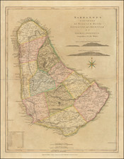
The "Map of the Island of Barbados," drawn by Reverend Griffith Hughes, is a detailed and informative representation of the island in the 18th century. Based on actual surveys and personal observations by Hughes, the map offers an in-depth view of the island's geography and societal makeup.

The map clearly outlines the eleven parishes of Barbados, each demarcated with distinct precision. The towns are marked, highlighting their spatial relationships to each other and the rest of the island's topography. Significant features, such as churches and forts, are dotted across the map, serving as reminders of the island's colonial era and religious landscape.

More than just human settlements, the map also spotlights the vibrant sugar industry that dominated Barbados in the 18th century. Detailed illustrations of sugar works, mills, and plantations showcase the island's primary economic engine. The web of roads connecting these places gives a sense of the logistic network and the labor-intensive nature of the industry.

The rivers of Barbados, while not abundant due to the island's geological characteristics, are carefully outlined. They often stretch from the highlands towards the coast, hinting at their importance for irrigation in the agriculture-centered economy.

Mountainous areas, though not as prevalent as on other Caribbean islands, are effectively depicted with shading and hachures to represent their relative heights. This gives the viewer a sense of the island's terrain, which, while not exceptionally steep, does feature gentle slopes and undulations.

Barbados in the 18th century was a bustling hub of trade and commerce. It was one of the wealthiest of the British colonies, thanks to its sugar, rum, and molasses production, as evidenced by the numerous plantations scattered across Hughes's map. African slaves were the backbone of these labor-intensive industries, though their existence is only implicitly suggested through the extensive infrastructure depicted.

Hughes, serving as the rector of St. Lucy's Parish from 1736, used his position to study and record the island's natural features, plants, and wildlife. His keen observations and meticulous detailing offer an invaluable perspective on Barbados's physical and human geography during this period.

This map is more than a navigational aid; it is an historical document that paints a picture of an era. It offers insights into the development of Barbados, revealing the intertwining of geography, industry, and colonial rule. Through Hughes's diligent work, we glimpse the 18th century Barbadian landscape, an island shaped as much by human endeavor as it is by its natural boundaries.

The Reverend Griffith Hughes (fl. 1707-1758) was a naturalist and author. He served as the rector of St. Lucy's Parish in Barbados from 1736 until his return to London. While on Barbados, he recorded his observations of the natural features, plants, and wildlife over a period of several years.

Thomas Jefferys Biography

Thomas Jefferys (c. 1719–1771) was a prolific map publisher, engraver, and cartographer based in London, known for his significant contributions to the cartography of North America and the West Indies during the 18th century. Jefferys was born to a cutler but was apprenticed to Emanuel Bowen, a prominent mapmaker and engraver. He gained his freedom from the Merchant Taylors’ Company in 1744, although he had already produced maps under his name as early as 1732. Throughout his career, Jefferys collaborated with several partners, including Thomas Kitchin, with whom he published The Small English Atlas in 1748-9, and Robert Sayer, with whom he co-created A General Topography of North America in 1768. Sayer also published posthumous collections featuring Jefferys' work, such as The American Atlas, The North-American Pilot, and The West-India Atlas.

Jefferys served as the Geographer to Frederick, Prince of Wales, and from 1760, to King George III. His role primarily involved supplying maps to the royal family, particularly during the height of the Seven Years' War, which spurred demand for detailed and accurate maps of North America. Jefferys not only sold maps commercially but also maintained connections with government bodies for whom he produced specialized materials, further solidifying his status in the map trade.

Despite his success and royal appointments, Jefferys faced financial difficulties, leading to bankruptcy in 1766. His business and map plates were eventually acquired by Robert Sayer and other associates. Upon Jefferys' death in 1771, his workshop passed to his son, Thomas Jr., and his partner, William Faden. Although Jefferys was known primarily as an engraver, producing illustrations and drawings in addition to maps, his contributions to the field of cartography remain his most enduring legacy.

Jefferys had no formal geographical training, and his early work was largely confined to engraving maps compiled by others or revising existing plates. However, his collaboration with John Green, a skilled cartographer also known as Bradock Mead, significantly enhanced his reputation. Mead, an Irishman with a complex personal history, was known for his expertise in map-making and was instrumental in creating some of the detailed maps that Jefferys published, including the influential New Map of Nova Scotia and Cape Britain in 1755. Mead's work underpinned much of Jefferys' acclaim as a leading map publisher of his time.

From 1750 onwards, Jefferys began to focus on maps of America, a region of increasing interest to British audiences. His notable works included a series of maps detailing North America, which bolstered his reputation as the preeminent map and chart supplier of his era. He continued to produce maps even after his financial collapse, but his later years were marked by financial instability. Despite this, his maps were in high demand and were republished by Sayer and Bennett, his former associates, who continued to use Jefferys' name to ensure commercial success.

Jefferys' legacy is characterized by his comprehensive atlases and detailed maps that captured the geographic and political landscapes of the 18th century. His work remains significant not only for its historical and cartographic value but also for its role in the broader narrative of colonial expansion and exploration. His contributions, preserved through subsequent editions and reprints, solidified his place as one of the leading figures in the history of cartography.