|
||

|

|
|

|
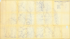
This "New Empire Series British Columbia" map, a large, color-lithographed wall map published by E.N. Moyer Company, Ltd., is a comprehensive representation of early 20th-century British Columbia. This circa 1915 (date roughly estimated) map, drawn and lithographed by George Philip & Son, Ltd. of London, paints a detailed landscape of settlements, transport routes, telegraph lines, and notable natural features across the Canadian province.
Initiating operations in 1912, E.N. Moyer Company, known as Canada's School Furnishers, produced a series of maps designed for educational use. This map, as part of the New Empire Series, was most likely utilized as a teaching tool in Canadian schools, helping students visualize the geographic distribution of communities and infrastructures within British Columbia. This period marked an era of expansion in the province, reflected in the details of this map.
The map's array of symbols and markers elucidate the population of towns, the distances between them, the presence of telegraphs, roads, trails, steamship routes, wireless stations, and altitudes in feet. It also highlights national parks and forest reserves, contributing to the understanding of the ecological diversity of British Columbia. The reference to railways, including the Canadian Pacific, Grand Trunk Pacific, Canadian Northern, Great Northern, White Pass & Yukon Route, and Pacific Great Eastern, portrays the pivotal role of railway connectivity in this era. It is possible that this list of railways could help determine a more exact date.
Additionally, the map delineates provincial boundaries, land districts, land recording divisions, electoral divisions, and mining divisions, providing a comprehensive overview of the administrative landscape of British Columbia during the early 20th century. A small inset in the upper right, titled "Continuation North-Westward On same scale as General Map," focuses on the region around the St. Elias Range, giving specific attention to this geographical feature.
This artifact, as a vivid representation of early 20th-century British Columbia, stands as a valuable resource for scholars of Canadian history, geography, and education, offering an intricate picture of the province's communities, infrastructures, and natural landscapes.
Rare
Evidently quite rare. We cannot find another example illustrated online.
![[Collection of 10 manuscript charts and maps depicting the west coast of North America from Monterey, California, to just north of Salisbury Sound, Alaska.]](https://storage.googleapis.com/raremaps/img/small/98898.jpg)