|
||

|

|
|

|
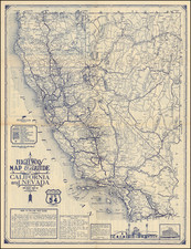
The Regional Aeronautical Chart 11M Restricted was compiled and printed in Washington, D.C. by the U.S. Coast and Geodetic Survey under the authority of the Secretary of Commerce. The map was created in collaboration with the U.S. Geological Survey and the Civil Aeronautics Administration.
This map was published on February 10, 1944, during World War II, and various warnings on the chart reflect the sensitive nature of air travel in this region during wartime. The chart covers Southern California and parts of Nevada and Arizona, and it includes significant cities like San Francisco, Los Angeles, San Diego, Phoenix, and Las Vegas.
The map is highly detailed and includes various symbols and markers that would have been crucial for aerial navigation. It shows radio stations, radio direction finder stations, seaplane ports, mooring masts, marine navigational lights, and more. Of note, there is a marking for a "vital defense area" along most of the coast of California, indicating the strategic importance of this region during the war.
The lines of equal magnetic variation would have been essential for correcting compass readings, a critical aspect of aerial navigation. Also, the presence of fan marker beacons and non-directional radio beacons would have provided radio navigation aids for aircraft.
This chart is on a 1:1,000,000 scale. From this aeronautical series, the present scale is less common than the 1:500,000 scale, making this map a bit of a rarity.
Given its date of publication, Restricted classification, and the marked "vital defense area," it's reasonable to suggest that this map could have played a role in the strategic planning and navigation for defensive operations in the region during World War II.