|
||

|

|
|

|
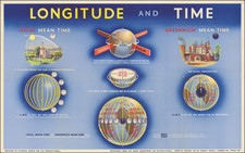
This "Longitude and Time" poster is part of the Geography Series from G.B. Instructional Wall Charts. Measuring 35 inches by 22 inches, it is a colorful and engaging educational resource. This chart is available for purchase at the price of 4/6 and can be obtained directly from the Chart Department of G.B. Instructional, located at Imperial House on 80-82 Regent Street, London.
This educational chart seeks to elucidate the relationship between longitude and time. It explains concepts such as Local Mean Time, Greenwich Mean Time, and the effect of the Earth's rotation on time zones. The chart communicates the principle that the Earth makes a complete turn in 24 hours, and that it is noon when the sun is highest overhead.
Further, the chart demonstrates that the Earth turns through 360 degrees in 24 hours, equating to a movement of 15 degrees per hour. It emphasizes that Local Mean Time (L.M.T.) is set by the sun at noon for places at the same moment in the same mean, whereas Greenwich Mean Time (G.M.T.) is set by the noon sun at Greenwich.
The chart also guides learners in understanding the relationship between Local Mean Time and the method to calculate longitude. It underlines that places west of Greenwich are behind G.M.T, while places east of Greenwich are ahead of G.M.T.
Designed by Pictorial Charts for G.B. Instructional, this educational resource provides learners with a comprehensive understanding of how time and geographical location are intertwined.
![Opusculum Geographicum Rarum [with map:] Universalis Orbis Descriptio, Cogimur e Tabula Pictos Ediscere Mundos.](https://storage.googleapis.com/raremaps/img/small/95970.jpg)