|
||

|

|
|

|
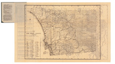
San Diego Electric Railway Company System Trackage Map, January 1925, drawn retrospectively by R.V. Dodge in 1956, provides a clear depiction of San Diego's electric railway network during the first quarter of the 20th century. The map delineates the operational electric lines and those no longer in use, as well as routes of notable steam railroads such as the Atchison, Topeka & Santa Fe Railway. Geographically, the chart spans areas from Fay Street and Prospect in La Jolla in the north to Kensington in the east and includes neighborhoods such as Coronado and Point Loma.
In the 1920s, electric railways were a common mode of transportation in many American cities, including San Diego. These railways enabled efficient movement across the city, linking various districts and communities. The presence of multiple rail systems, such as the San Diego & Arizona Railway and the National City & Otay Railway, highlighted the interconnected nature of transportation within the region. The map's indication of certain abandoned trackage reflects shifts in transportation patterns and needs over time.
This map serves as a concise historical document, shedding light on San Diego's transportation infrastructure and the role of electric railways in the city's development. Many of the routes are now lost, paved over by regular city streets, and this is an important record of where they once extended.