


|
||

|

|
|

|
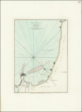
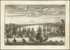
Plan of Ponta de Gala and Plan of the Bay of Nilewelle, both delineating specific sections of the south coast of Ceylon, were derived from the maps of the Van Keulen family. Published in May 1794 by Laurie & Whittle in London, these representations offer a precise view of the topographical features and maritime nuances of these regions during the closing years of the 18th century.
The late 18th century marked a pivotal period in the history of Ceylon, now recognized as Sri Lanka. The island, situated strategically along key maritime trade routes, drew the interest of major European powers, notably the Portuguese, Dutch, and the ascending British empire. The Van Keulen firm's cartographic expertise was largely centered on nautical charts, emphasizing the importance of these coasts for navigational and trade purposes.
By presenting Ponta de Gala and the Bay of Nilewelle on one sheet, the cartographers highlighted the geographical adjacency and interconnected relevance of these areas. During this period, the influence of the British was steadily growing in the Indian Ocean, making accurate maps essential for navigation, trade, and territorial control. The publication of these detailed coastal maps by Laurie & Whittle, a renowned entity in the cartographic publishing realm, further underscores the contemporary demand and utility of such precise geographical information.
Robert Laurie (ca. 1755-1836) and James Whittle (1757-1818) formed their Fleet Street, London-based firm upon the 1794 death of their employer Robert Sayer, himself one of the dominant print and mapmakers of the last half of the 18th century.
Laurie & Whittle started managing Sayer's business as early as 1787. They took over all managerial duties when Sayer's health flagged in 1792, and they changed the imprint in 1794 upon his death. Sayer left the two a 21-year lease on the shop (at £100 a year) and on Sayer's Bolt Court premises, as well as an option to acquire stock and equipment at a preferential price of £5,000 payable over three years.
Robert Laurie retired from the firm in 1812, and his role was assumed by his son, Richard Holmes Laurie (1777-1858). The younger Laurie worked with James Whittle until the latter died in 1818. After R. H. Laurie died in 1858, Alexander George Findlay, FRGS (1812-1875) purchased the firm from his daughters. The firm continues today under another name, specializing in yachting charts.
Laurie & Whittle were prolific print and map publishers, and throughout their careers, they produced numerous very important and rare works. They carried on Robert Sayer's atlas business and were responsible for editions of The Complete East-India Pilot and The American Atlas.
![(Sri Lanka) Plan of Ponta de Gala, on the South Coast of Ceylon [with] Plan of the Bay of Nilewelle, on the South Coast of Ceylon](https://storage.googleapis.com/raremaps/img/small/94806.jpg)