


|
||

|

|
|

|
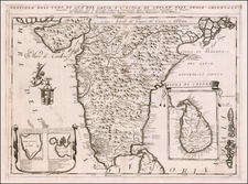
Rare English Sea Chart of the Harbor and Environs of Colombo, Sri Lanka
Striking sea chart depicting the strategic harbor of Colombo during a time of significant geopolitical and trade transformations. Colombo, known in the 18th century for its harbor, was a focal point of colonial interests and trade routes. This period was marked by the waning influence of the Dutch East India Company and the burgeoning power of the British Empire in the region.
During the 18th century, Colombo emerged as a vital port city under Dutch colonial rule. The Dutch consolidated their control over the coastal areas of Ceylon (now Sri Lanka) and fortified Colombo as a central node in their maritime trade networks, dealing in cinnamon, ivory, and other exotic goods. The port's significance was due to its strategic location along the East-West sea trade routes and its capacity to service and provision ships.
By the late 1700s, the British, who had already established their presence in other parts of India, recognized the strategic importance of Ceylon and its harbors, including Colombo, which were essential for maintaining dominance over sea routes and protecting their economic interests in Asia. The transition of power from Dutch to British control in 1796 marked a pivotal shift in Colombo's geopolitical status, laying the groundwork for its later development under British colonial rule.
The sea chart itself, with its detailed depiction of the coastline and depth soundings, was an important tool for navigation and military strategy, helping to guide merchant ships and naval vessels into the harbor.
Robert Laurie (ca. 1755-1836) and James Whittle (1757-1818) formed their Fleet Street, London-based firm upon the 1794 death of their employer Robert Sayer, himself one of the dominant print and mapmakers of the last half of the 18th century.
Laurie & Whittle started managing Sayer's business as early as 1787. They took over all managerial duties when Sayer's health flagged in 1792, and they changed the imprint in 1794 upon his death. Sayer left the two a 21-year lease on the shop (at £100 a year) and on Sayer's Bolt Court premises, as well as an option to acquire stock and equipment at a preferential price of £5,000 payable over three years.
Robert Laurie retired from the firm in 1812, and his role was assumed by his son, Richard Holmes Laurie (1777-1858). The younger Laurie worked with James Whittle until the latter died in 1818. After R. H. Laurie died in 1858, Alexander George Findlay, FRGS (1812-1875) purchased the firm from his daughters. The firm continues today under another name, specializing in yachting charts.
Laurie & Whittle were prolific print and map publishers, and throughout their careers, they produced numerous very important and rare works. They carried on Robert Sayer's atlas business and were responsible for editions of The Complete East-India Pilot and The American Atlas.
![[Jaffna, Sri Lanka] Jaffenapatnam](https://storage.googleapis.com/raremaps/img/small/76226.jpg)
![[Sri Lanka] Ceylon](https://storage.googleapis.com/raremaps/img/small/74202.jpg)