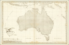
|
||

|

|
|

|
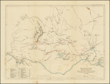
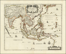
Chart of the South Channel From Prince of Wales's Island to Sea by Capt. H.R. Popham, published in London by Laurie & Whittle on Fleet Street in 1798, delineates a crucial navigational corridor with topographical precision, demonstrating the interplay between maritime exploration and British colonial endeavors at the cusp of the 19th century. Highlighting pivotal landmarks such as buoys, sands, and mud flats, this chart provides an in-depth view of the South Channel, emphasizing its strategic significance in navigation.
During the late 18th century, British maritime explorations were inextricably linked with their colonial ambitions. Prince of Wales's Island, now known as Penang, emerged as a strategic British naval base in Southeast Asia. Its prime position at the crossroads of major shipping routes rendered it an invaluable asset, and this chart embodies the thoroughness with which the British endeavored to document these channels for their expanding empire.
In addition to the meticulously plotted course of the South Channel, the chart furnishes an inset titled Plan of Fort Cornwallis with The Town on the East Point of the Island. Fort Cornwallis (now Georgetown), dominating the illustration, was a linchpin in the defense and administration of the newly acquired British territories in the region. The mention of infrastructure elements such as the Portuguese Church, China Street, and various administrative buildings reveals a microcosm of the complex intercultural interactions and layered colonial history of the island.
The cartographic specificity extends beyond just the terrestrial, as the chart makes note of various maritime markers – from the Praya Buoy to the Mud Flat Buoy – which would have been indispensable for sailors and merchants navigating these waters. The emphasis on "The Passage between Long Sand and Praya Sand" underscores the perils and challenges that even the most seasoned mariners would have encountered in this region, showcasing the chart's role as both an artistic and functional artifact.
In sum, Capt. H.R. Popham's chart offers a comprehensive view into the British Empire's maritime strategies in Southeast Asia at the turn of the 19th century, revealing how cartography and colonial ambitions were symbiotically intertwined. The item serves as an evocative testament to the intersection of exploration, empire, and the human quest for understanding and documenting the world.
Laurie and Whittle and the East Indian Pilot
Produced by the partnership of Robert Laurie and James Whittle, who took over Robert Sayer's business in 1794, this chart and the East India Pilot series it belongs to were important navigational resources during the height of British seafaring trade and exploration in the East Indies. It reflects the significant efforts of Laurie & Whittle to provide accurate, practical maps for maritime navigation, particularly in the highly trafficked, strategically critical waters of present-day Indonesia.
The partnership of Laurie and Whittle, later taken over in full by Richard Holmes Laurie, marked a critical phase in the history of British cartography characterized by the advent of modern, scientific topography. They collaborated with many of the other foremost British mapmakers of the day, including Kitchin, Faden, and Jefferys.
Robert Laurie (ca. 1755-1836) and James Whittle (1757-1818) formed their Fleet Street, London-based firm upon the 1794 death of their employer Robert Sayer, himself one of the dominant print and mapmakers of the last half of the 18th century.
Laurie & Whittle started managing Sayer's business as early as 1787. They took over all managerial duties when Sayer's health flagged in 1792, and they changed the imprint in 1794 upon his death. Sayer left the two a 21-year lease on the shop (at £100 a year) and on Sayer's Bolt Court premises, as well as an option to acquire stock and equipment at a preferential price of £5,000 payable over three years.
Robert Laurie retired from the firm in 1812, and his role was assumed by his son, Richard Holmes Laurie (1777-1858). The younger Laurie worked with James Whittle until the latter died in 1818. After R. H. Laurie died in 1858, Alexander George Findlay, FRGS (1812-1875) purchased the firm from his daughters. The firm continues today under another name, specializing in yachting charts.
Laurie & Whittle were prolific print and map publishers, and throughout their careers, they produced numerous very important and rare works. They carried on Robert Sayer's atlas business and were responsible for editions of The Complete East-India Pilot and The American Atlas.