


|
||

|

|
|

|
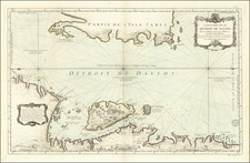
Second state of Hondius' decorative map of the South Polar region, predating the first appearance of New Zealand and Van Diemen's Land, from the 1644/45 German edition of Jansson's Novus Atlas.
The map shows all but two of the known Dutch discoveries up to 1627, including those of Pieter Nuyts, Frederick de Houtman, Dirk Hartog, and Jan Fransz's Leeuwin south of the 20th parallel south. Omitted are the voyages of Jansz and Roossengin in 1605-06 and Cartensz and van Colster in 1623. Gerritt Frederikszoon de Witt's explorations in 1628 are also absent. Saint Helena, the Disappointment Islands, and Le Maire's discovery of the Tongan archipelago, all above the 20th parallel, are shown outside the circular perimeter. The supposed coastline of the unknown southern continent appears as a splintered, hachured line, nearly touching Tierra del Fuego. Includes notes regarding the affirmation of the discovery of islands by Magellan and Hernando Gallego. Vignettes filling the four corners purportedly depict various native scenes spanning the region.
A gorgeous full-color example of this early South Polar map, which is a veritable textbook of mythical and conjectural cartography, blended with early Dutch discoveries in the region.
Jan Janssonius (also known as Johann or Jan Jansson or Janszoon) (1588-1664) was a renowned geographer and publisher of the seventeenth century, when the Dutch dominated map publishing in Europe. Born in Arnhem, Jan was first exposed to the trade via his father, who was also a bookseller and publisher. In 1612, Jan married the daughter of Jodocus Hondius, who was also a prominent mapmaker and seller. Jonssonius’ first maps date from 1616.
In the 1630s, Janssonius worked with his brother-in-law, Henricus Hondius. Their most successful venture was to reissue the Mercator-Hondius atlas. Jodocus Hondius had acquired the plates to the Mercator atlas, first published in 1595, and added 36 additional maps. After Hondius died in 1612, Henricus took over publication; Janssonius joined the venture in 1633. Eventually, the atlas was renamed the Atlas Novus and then the Atlas Major, by which time it had expanded to eleven volumes. Janssonius is also well known for his volume of English county maps, published in 1646.
Janssonius died in Amsterdam in 1664. His son-in-law, Johannes van Waesbergen, took over his business. Eventually, many of Janssonius’ plates were sold to Gerard Valck and Pieter Schenk, who added their names and continued to reissue the maps.
![[ Australia ] Australien](https://storage.googleapis.com/raremaps/img/small/98068.jpg)
![[ Antarctic Regions - Shackleton ] British Antarctic Expedition 1907 -- General Map showing the Explorations and Surveys of the Expedition 1907-1909](https://storage.googleapis.com/raremaps/img/small/99613.jpg)
![Russiae et Novae Zemlae Maritimae [Maritime Russia and Novaya Zemlya.]](https://storage.googleapis.com/raremaps/img/small/92722.jpg)