|
||

|

|
|

|
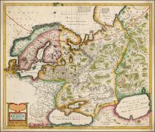
A scarce, beautifully engraved chart of the Russian Arctic published in Amsterdam in 1745 by Reiner & Joshua Ottens. This map is oriented with east at the top and focuses on Russia's Arctic coast, spanning from Lapland to Nova Zembla, also known as Novaya Zemlya.
One of the most striking features of the chart is the dramatic cartouche in the upper right corner. It showcases an intense scene involving polar bears, walruses, and foxes engaging in combat with Arctic explorers. This vivid illustration captures the imagination and gives a sense of the challenges that people faced in this harsh region.
The Ottens brothers, Reiner and Joshua, operated a successful printing partnership in the mid-eighteenth century (fl. 1726-1765). They began the venture in 1726, publishing maps and other prints as “R & I Ottens.” They specialized in the reprinting of others’ work, especially Guillaume De L’Isle. In 1750, Reiner died; his soon, also Reiner, took his place, but the firm began listing their works as “Joshua & Reiner Ottens.” The firm lasted until Joshua’s death in 1765. Joshua’s widow, Johanna de Lindt, sold their remaining stock of plates in 1784.
![[St. Petersburg, Russia]. Grond-Tekening van de Russische Hoosdstadt St. Petersburg, door Czaer Pieter de Eerstre In't Jaer 1703 aengelegt. . . . .](https://storage.googleapis.com/raremaps/img/small/40904.jpg)