|
||

|

|
|

|
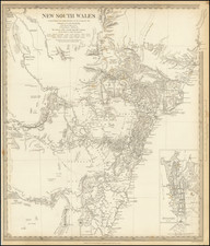
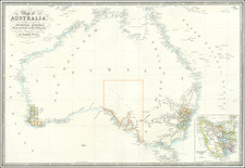
A rare 1863 wall map of Australia, New Zealand, and adjacent islands, published by the Society for Promoting Christian Knowledge.
The map covers the area from Singapore in the northwest corner to New Caledonia and New Zealand in the east and south, with Australia taking pride of place in the center.
The map includes much detail in Australia, including named and dated up through 1862.
Dating
Before 1863, when Northern Territory was transferred to South Australia (that configuration can be seen in an 1880s edition held by the National Library of Australia). Queensland separated from New South Wales on June 6, 1859. The map includes numerous dated routes and settlements up to 1862, indicating a date of 1863. This is in keeping with the records we have found in OCLC.
Rarity
The National Library of Australia and the Alexander Turnbull Library-National Library of New Zealand hold examples of the 1863 edition.