|
||

|

|
|

|
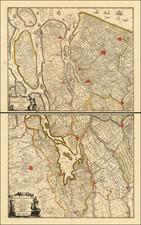
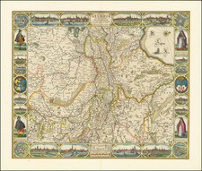
Fascinating map illustrating a proposed canal from Utrecht to Spakenburg and the sea, a remarkable testament to Dutch vision and ambition in the period of exploration.
This title translates to "New and Neat Drawing of the Excavation that is to take place beginning from the City of Utrecht to Spakenburg in the Zuiderzee with its demarcation, etc.
The "Nieuwe en Nette Aftekening" map illustrates the proposed canal's path, beginning in Utrecht and terminating in the Zuiderzee, a large shallow inlet of the North Sea, at Spakenburg. This canal was not just a practical idea for transportation and trade but also a symbol of Dutch ambition. The meticulous detail of the map, showing the geographical features, proposed path, and adjacent settlements, reflects the careful planning that went into this audacious proposal.
At the time, the Netherlands was a leading maritime power. The creation of such a canal, linking the city of Utrecht directly to the sea, was a grand project aimed at reinforcing this status. The canal would have facilitated trade, navigation, and military transport, cementing Dutch dominance in the region.
Joachim Ottens (1663-1719). Alongside his sons, Joachim was a part of the esteemed Ottens family, who made significant contributions to the golden age of Dutch cartography. Joachim's maps were renowned for their detail, accuracy, and artistic value, capturing the spirit of exploration and human curiosity that defined the era.
![Belgium Foederatum auctius et emendatius… [Large inset of SE Asia]](https://storage.googleapis.com/raremaps/img/small/89316.jpg)