


|
||

|

|
|

|
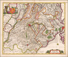
A finely detailed map of Zeeland, published in Amsterdam, circa 1700.
The map outlines the islands and municipalities of Walcheren, Schouwen-Duiveland, Noord-Beveland, Wolfersdyck, Zuid-Beveland, Goeree-Overflakkee, Tholen, Cadzand, etc. Main cities and towns are highlighted in red including Middelburg, Veere, Goes, Zierikzee, Vlissingen, Brouwershaven, Bergen op Zoom, Tholen, etc.
The map features many topographical features such as lakes, waterways, mountains, hills, pathways, and canals.
A decorative title cartouche, scale of miles, and three compass roses are engraved on the map.
Pierre, or Pieter, Mortier (1661-1711) was a Dutch engraver, son of a French refugee. He was born in Leiden. In 1690 he was granted a privilege to publish French maps in Dutch lands. In 1693 he released the first and accompanying volume of the Neptune Francois. The third followed in 1700. His son, Cornelis (1699-1783), would partner with Johannes Covens I, creating one of the most important map publishing companies of the eighteenth century.
![[Holland and the Kingdom of Belgium or the Netherlands] L'Olanda e il Regno Belgico ovvero i Paesi Bassi](https://storage.googleapis.com/raremaps/img/small/82726.jpg)
![Deutschland un die Niederlande von Bauerkeller [Germany and the Netherlands by Bauerkeller]](https://storage.googleapis.com/raremaps/img/small/88180.jpg)
![[ Lower Rhine River & Wesser River Region ] Die dritte Tafel des Rheinstroms / Innhaltend das Nider Teutschlandt](https://storage.googleapis.com/raremaps/img/small/81288.jpg)