|
||

|

|
|

|
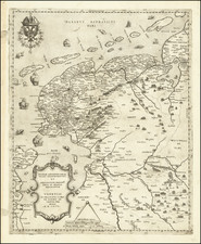
Rare carte-a-figures map of the Duchy of Guelders and County of Zutphen, published by Claes Janszoon Visscher and engraved by Abraham Goos.
The map is oriented with west at the top and shows the region which includes the Rhine River, Leck River, Maas River and Wael River. The engraved borders show 16 city views (Roermond, Zutphen, Wachtendonk, IJsseloord, Lochem, Breevoort, Geldern, Harderwijk, Bommel, Tiel, Groenlo, Veenlo, Knodsenburg, Wageningen, Nijmegen and Arnhem), 4 fortresses, 4 persons in their traditional costume: a man and woman from Guelders and a man and woman from Zutphen, and the coat of arms of Guelders and of Zutphen
The entire province of Gelderland with the overkwartier or Oppergelre is clearly demarcated. Count Hendrik van den Berg's campaign to the village of Ede, which he set on fire with the aim of getting Frederik Hendrik away from 's Hertogenbosch, is shown on this map.
The map was first issued about 1630.
![[Proposed Canal / Utrecht to the Sea] Nieuwe en Nette Aftekening van de Door Gravinge die er staat te Geschieden beginnende van de Stadt Utrecht to aan Spakenborg in de Zuyder Zee met des zelfs Afbakinge &c](https://storage.googleapis.com/raremaps/img/small/94380.jpg)