


|
||

|

|
|

|
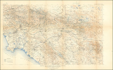
Scarce locally-published map of Tulare County, California, published by H. Levinson in Visalia, California, in 1907. The map provides a detailed representation of the county, including geographic features, roads, railroads, irrigation districts, and other points of interest.
The map features labels for various locations, such as McWhitney and Le Conte, as well as references to Sheep Mountain (Sheep M). Additionally, it highlights different types of roads, including railroads (represented by dashed lines), standard roads, and trails. Irrigation ditches and districts are also marked on the map.
Tulare County is divided into supervisor districts, which are numbered and labeled on the map. Schoolhouses within the county are also indicated.
The map shows the Tule River running through the county and marks an Indian Reserve area. Furthermore, it includes a note mentioning that the map's production involved photo lithography by Britton & Rey, B.F.
Overall, this 1907 map of Tulare County, California, provides valuable information about the area's geography, infrastructure, and points of interest at the beginning of the 20th century.
Rarity
The map is extremely rare.
OCLC locates 1 example of the 1902 edition only.
![National Map Company's California Showing Counties, Cities, Villages, and Post Offices[,] Steam and Electric Railroads, with Stations and Distances between Stations[,] National Forests, Reservations, Parks, Etc.](https://storage.googleapis.com/raremaps/img/small/92408.jpg)

![(California Gold Rush Artist) [Autograph Letter, from American artist William McIlvaine Jr. to artist William Thompson Russell Smith, mentioning Fronconia Notch. White Mountains]](https://storage.googleapis.com/raremaps/img/small/97179.jpg)