


|
||

|

|
|

|
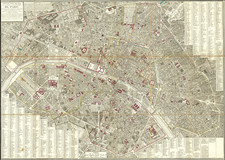
Stunning large format map of Paris, published by Frederick De Wit in Amsterdam.
Centered on the Seine River, the map illustrates Paris at the end of the 17th Century, with two large tables identying hundreds of street names and buildings. The map includes two large coats of arms of France and the City of Paris.
A striking map of Paris, first issued by Joannes de Ram from 1690. Notably absent from this depiction are the 'Place des Victoires' and 'Place Vendome,' indicating the plan's portrayal of the city's geography circa 1685, following the work of Jouvin de Rochefort.
This same copper plate was also used by Justus Danckerts, Carel Allard, Jacques de la Feuille, and, around 1700, by Frederik de Wit himself, and finally by Pieter van der Aa in his "La Galerie Agréable du Monde" around 1729.
De Wit (1629 ca.-1706) was a mapmaker and mapseller who was born in Gouda but who worked and died in Amsterdam. He moved to the city in 1648, where he opened a printing operation under the name of The Three Crabs; later, he changed the name of his shop to The White Chart. From the 1660s onward, he published atlases with a variety of maps; he is best known for these atlases and his Dutch town maps. After Frederik’s death in 1706, his wife Maria ran the shop for four years before selling it. Their son, Franciscus, was a stockfish merchant and had no interest in the map shop. At the auction to liquidate the de Wit stock, most of the plates went to Pieter Mortier, whose firm eventually became Covens & Mortier, one of the biggest cartography houses of the eighteenth century.
![[Paris Environs - Southeast] Carte Routiere pour Automobilistes & Cyclistes -- Environs de Paris Section Sud-Est](https://storage.googleapis.com/raremaps/img/small/95862.jpg)
![[Paris World's Fair] Exposition Universelle de 1900 -- Plan General](https://storage.googleapis.com/raremaps/img/small/92123.jpg)
![(Paris) 5.e Arrondissement. Vue Prise Au Dessus de L'Eglise Bonne Nouvelle [5th Arrondissement. View taken from above the Bonne Nouvelle Church.]](https://storage.googleapis.com/raremaps/img/small/81820.jpg)
![[Paris -- With Manuscript Additions Showing The 20 Departments] Plan Routier De La Ville et Faubourg De Paris 1777 . . .](https://storage.googleapis.com/raremaps/img/small/70471.jpg)