


|
||

|

|
|

|
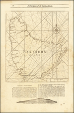
Striking example of Herman Moll's map of Barbados, published in London in the early 18th century.
Barbados was first sighted by the Portuguese explorer Pedro Campos in 1536, but it wasn't until the 1620s that the English began to settle there. The island was initially used as a tobacco plantation, but this crop was quickly replaced by sugar cane, which became the island's main export.
By the early 18th century, Barbadoes had become one of the wealthiest British colonies in the Caribbean, with a thriving sugar industry and a large enslaved African population. The island's prosperity attracted the attention of other European powers, and it was frequently attacked by the French and the Dutch throughout the 17th and 18th centuries.
Herman Moll's map of Barbadoes provides a detailed look at the island's geography, including its coastline, rivers, and mountains. It also includes information on the island's sugar plantations, towns, and forts, as well as the location of the various European settlements and the territories of the indigenous Carib people.
One of the most interesting features of the map is the depiction of the island's roads and transportation network, an unusual feature for a map of this period.
Herman Moll (c. 1654-1732) was one of the most important London mapmakers in the first half of the eighteenth century. Moll was probably born in Bremen, Germany, around 1654. He moved to London to escape the Scanian Wars. His earliest work was as an engraver for Moses Pitt on the production of the English Atlas, a failed work which landed Pitt in debtor's prison. Moll also engraved for Sir Jonas Moore, Grenville Collins, John Adair, and the Seller & Price firm. He published his first original maps in the early 1680s and had set up his own shop by the 1690s.
Moll's work quickly helped him become a member of a group which congregated at Jonathan's Coffee House at Number 20 Exchange Alley, Cornhill, where speculators met to trade stock. Moll's circle included the scientist Robert Hooke, the archaeologist William Stuckley, the authors Jonathan Swift and Daniel Defoe, and the intellectually-gifted pirates William Dampier, Woodes Rogers and William Hacke. From these contacts, Moll gained a great deal of privileged information that was included in his maps.
Over the course of his career, he published dozens of geographies, atlases, and histories, not to mention numerous sheet maps. His most famous works are Atlas Geographus, a monthly magazine that ran from 1708 to 1717, and The World Described (1715-54). He also frequently made maps for books, including those of Dampier’s publications and Swift’s Gulliver’s Travels. Moll died in 1732. It is likely that his plates passed to another contemporary, Thomas Bowles, after this death.
![Guadaloupe [with] Antigua [with] Mariegalante &c.](https://storage.googleapis.com/raremaps/img/small/72024.jpg)
![West India Islands [Curacao, Trinidad, Grenada and Tobago] [4 maps on 1 sheet]](https://storage.googleapis.com/raremaps/img/small/48137.jpg)