|
||

|

|
|

|
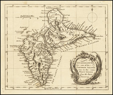
The First Printed Map of Mari-Galante
This extremely rare and visually striking map, titled "L'isle de Mariegalande 1667," illustrates the island of Marie-Galante, which is part of modern-day Guadeloupe, in the West Indies.
The map is intricately detailed, with relief shown pictorially and north oriented to the upper right. It showcases various elements, such as roads, plantations, swamps, and topographical features, providing a comprehensive understanding of the island's layout during the 17th century. Additionally, the map features an inset diagram of fortifications and several decorative elements, including griffins, a crown, a detailed warfare scene, and two coats of arms, one of which represents France.
Created by François de La Pointe and published by Thomas Jolly in 1667, the map offers a valuable insight into the historical context of Marie-Galante and its connection to French colonial ambitions in the West Indies. The island was governed by Mr. de Temericourt at the time, and its representation in Jean Baptiste Du Tertre's "Histoire generale des Antilles habitées par les Francois ... Tome II" underscores the importance of the French presence in the region. The map serves not only as a geographical guide but also as a testament to the era's colonial endeavors, providing a window into the complex relationships between European powers and the territories they sought to control.
Du Tertre was sent by the Dominicans as a missionary to the Antilles, where he stayed from 1640 until 1658. His book was described by Sabin as "One of the most valuable [works] we possess on the West Indies." The work is scarce, the final volume, issued in 1671 with additional maps, is very quite rare.
Coronelli copied this map in the 1680s and early 1690s.
Rarity
This is the first time we have offered this map for sale.
![[ Rare Sailing Directions ] Barbados. W.I. Compiled from Admiralty Sheet 1884. Hanschell & Co. Sail and Steam Agents Barbados [with] Bridgetown](https://storage.googleapis.com/raremaps/img/small/99569.jpg)
![[St. Barths, Nevis, St. Martins, St. Kits, Antigua, Barbuda, Anguilla, Guadalupe, Dominica, etc.] Geographical, Statistical and Historical Map of The Leeward Islands](https://storage.googleapis.com/raremaps/img/small/52732.jpg)