


|
||

|

|
|

|
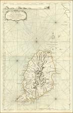
Detailed map of the Islands of Guadaloupe, Antigua, Mariegalante and the Isles de Saintes.
Excellent topographical and geographical details, including smaller islands, harbors, coves, reefs, points, towns, ponds, rivers, parishes, divisions, etc.
John Thomson (1777-ca. 1840) was a commercial map publisher active in Edinburgh. He specialized in guide books and atlases and is primarily known for his Atlas of Scotland (1832) and the New General Atlas, first published in 1817 and reissued for the next quarter century. The New General Atlas was a commercial success—it was also published in Dublin and London—and it compiled existing geographic knowledge in compelling ways for a wide audience.
His Atlas of Scotland introduced new geographic information and was the first large-scale atlas of Scotland to be organized by county. It provided the most-accurate view of Scotland available before the Clearances. Work on the atlas began in 1820 and led to Thomson’s bankruptcy in 1830 due to the high costs of gathering the latest surveys and reviewing the required materials. Despite the publication of the atlas, Thomson declared bankruptcy again in 1835.
![[Barbados] Carta De La Isla De La Barbada Reducida y Gravada Por D. Juan Lopez . . . 1780](https://storage.googleapis.com/raremaps/img/small/85048.jpg)

![[ Virgin Islands, etc ] Supplément pour les Isles Antilles, extrait des cartes Angloises](https://storage.googleapis.com/raremaps/img/small/98774.jpg)
![Martinico [and] Dominica](https://storage.googleapis.com/raremaps/img/small/85250.jpg)
![[ Rare Sailing Directions ] Barbados. W.I. Compiled from Admiralty Sheet 1884. Hanschell & Co. Sail and Steam Agents Barbados [with] Bridgetown](https://storage.googleapis.com/raremaps/img/small/99569.jpg)