|
||

|

|
|

|
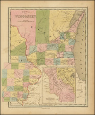
Arguing Future Growth Potential Through Comparative Maps
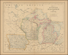
Fascinating map of the area 75 miles around Sioux City, with smaller maps of the area around Omaha and Kansas City, prepared as part of an informative 32 page pamphlet, with illustrations, promoting Sioux City, Iowa in December 1892.
The map shows the counties (with populations), railroads and rivers and other cities around each of the three cities, apparent intention of illustrating how Sioux City an "Unoccupied Area Larger than that of Any other Northwestern City" and "No Satellites To Detract From It."
The map and text present a fascinating argument regarding the future growth prospects of Sioux City. The map and accompany text highlight the strategic positioning and future potential of Sioux City as a leading commercial and railroad center in the Missouri Valley. Based on a series of maps, the author argues that Sioux City possesses superior railroad facilities and less regional competition compared to other cities, such as Omaha and Kansas City. By being the hub from which many railroads radiate, Sioux City is predicted to grow as a commercial powerhouse, with strong influence over its surrounding territory, in comparison to Omaha and Kansas City, which have greater competition. Its location at the intersection of three states (Nebraska, Iowa, and South Dakota), and an environment conducive to agriculture, further strengthens its future prospects. Despite rivals, the text suggests Sioux City's growth and development align with the laws that govern the evolution of cities, positioning it to become a leading city in the Missouri Valley.
The text at the left of the map tells the story:
THE most convincing proof that Sioux City is today the leading railroad center of the Missouri Valley is furnished by a glance at a map fairly showing the situation as it is.
F. C. Hills, director of the Sioux City, Chicago and Baltimore and ex-president of the Sioux City and Northern railroad companies, is the originator of a suggestive argument on this point. It consists simply of a series of three small maps, showing Sioux City, Omaha and Kansas City, each in the center of a circle with a seventy-five-mile radius. All the railroad lines and all the cities large enough to be entitled to consideration as commercial centers, are shown on each map. The design is to show the railroad facilities of each of the three cities, the competing commercial points in the immediate neighborhood of each, their size, and their railroad facilities as compared with those of the city at the center of the circle. From these facts the deduction as to the probable future of each city is easy.
The series of maps prepared under Mr. Hills' directions is here presented. A brief study of them will convince the reader of the accuracy of Mr. Hills' conclusion that Sioux City has better railroad facilities and far less competition in its own immediate territory than either of the cities with which comparisons are made.
The map of Sioux City's territory shows this point as the center of a circle 150 miles in diameter, in which there is not a single point of which the railroad facilities, population or natural location, suggests it as in any measure a competitor for commercial supremacy. All roads lead to the center and from it they radiate in every direction, like spokes from a hub. The city is thus made by the railroads the commercial center of a territory of which the river valleys converging here make it the natural center. So perfect is this railroad system and so entirely is it subserved to the interests of the city at its center, that there is no possibility of rival cities being developed in the same vicinity to detract from the one at the hub. Yet this surrounding territory while sparsely settled and as yet but partially developed, contains many thriving towns, all of which look to Sioux City as their jobbing and financial headquarters. Thus, while the country is still in its infancy, Sioux City has established itself, and has come to be recognized as the transportation, commercial and wholesaling center. The development of the railroad system, as yet little more than well begun, is being carried forward with reference to Sioux City. New lines are planned, as shown on the map, in every direction. Some of them may not be built, but others will be, and every mile of rails added to the system that centers at Sioux City will tighten the hold of the city on the commercial scepter of the surrounding empire.
The map of Sioux City's territory is an absolutely accurate one; it is reproduced from the railroad commissioner's maps of Iowa and Nebraska, and from Rand, McNally & Co's., maps of South Dakota. Those of Omaha and Kansas City are similarly exact, the data having been gathered from similar sources. But the difference between the situation of these points and Sioux City is striking. Omaha is surrounded by towns competing for the trade of the territory on which it must depend. Council Bluffs, on the Iowa side of the river cuts off the trade to the east. To the south is Nebraska City with 11,000 people, and Plattsmouth with 8,000; Beatrice, to to the southwest, 13,000; Lincoln, just at Omaha's back door and admirably located with reference to cutting off the trade of the city, has nearly half the population of Omaha, and is rapidly becoming a rival of the latter place in every commercial sense. To the northwest of Omaha is Fremont, standing between Omaha and the trade in that direction.
Each of these points mark the convergence of a number of railroad lines, each is ambitious to develop its possibilities and to command the trade of its particular section and each is moving in this direction.
Omaha as a railroad center does not compare with Sioux City, as is shown by the map. Inside the seventy-five-mile radius about Omaha are half a dozen points, each of which rivals Omaha in point of railroad facilities. The Milwaukee, Rock Island and Northwestern lines run to Council Bluffs; the Northwestern, however, has its Missouri river crossing twenty-five miles north of Omaha at Blair. Its passenger trains come to Omaha over the Pacific bridge, but the great bulk of its freight is crossed on the Blair bridge, and does not pass through Omaha. At present the Milwaukee and Rock Island enter Omaha over the Union Pacific bridge, but it is not many months since they were shut out of Omaha entirely. The present arrangement is not a sure or permanent one.
At Kansas City the situation is, if possible, still worse. Just across the state line Kansas City, Kansas, 38,000 people; the north is St. Joe, with 52,000 people and good railroad facilities. Its jobbing trade extends all through the territory of Kansas City, and is said to be even larger than that of the latter place. It is the most formidable rival of Kansas City, yet hardly more so than Leavenworth, which is but half as far sway and has 19,000 people, and Topeka, almost due west of Kansas City, with 31,000. Lawrence, with 10,000 people, is almost half way between Kansas City and Topeka, and lies between Kansas City and its trade to the southwest.
Each of these satellite cities is a railroad city. It has its system of roads, which give it a tributary section peculiarly Its own, in which it carries on business to greater advantage than any other point.The territory surrounding Omaha and Kansas City is in no wise superior to or capable of supporting a greater number of people than that contiguous to Sioux City. With the assurance, which its railroads give, that Sioux City is to be the one city of its territory, with no rivals to draw its trade and sap its energies, it appears plain that Sioux City, when its territory is developed, will be the leading city of the Missouri valley.
Mr. Hills who has made a study of the geography of the United States with reference to the laws that govern the location of great cities, is convinced that this will be proved by the developments of the next decade. Of Sioux City's future, and of the reasons which gave him this confidence, he says:
It is universally conceded and statistics prove, that there is no finer and more productive agricultural region on the face of the globe than that of which Sioux City is the center. Situated, as it is, at the confluence of the Big Sioux and Floyd rivers, with the Missouri, and which river, from the mouth of the Niobrara, over 100 miles west, runs to Sioux City in an easterly direction, thence makes almost a right angle, turns and runs south, and while Sioux City is located on the east bank of the river, and has steadily grown to its present magnitude, contrary to the expectation and prophecies of those who believe that no important city can grow up on the east bank of any navigable stream, its growth and development have determined that its founders carefully studied the geo-graphical situation and that their judgment was in accordance with the laws that govern the growth of cities.
Located at a point where the three states of Nebraska, Iowa and South Dakota meet, while situated in Iowa, it is a city of three states, and the citizens feel fully as much if not more interest in Nebraska and South Dakota as they do in Iowa. It is the commercial and financial city for the large agricultural region extending from central Iowa on the east to the Rocky mountains on the trest, and from the Platte river in Nebraska and Wyoming on the south to the northern boundary of South Dakota on the north, and its people are bound together by ties of sympathy, friendship and business. Geographically its location is correct, and its resources are abundant to justify a firm belief that it will continue to occupy relatively the same position to the surrounding country that it has from its infancy. The fertility of the soil, with every acre tillable, compared with older states, and the young and energetic class of people considered, the following figures are suggestive of its future: The last census returns show that New York state, leaving out the population of New York and Brooklyn, (which are national cities) has a population of 80 to the square mile; Ohio, 80; Indiana, 60; Illinois, leaving out Chicago, the city of the northwest, 50; Iowa, 34; Nebraska, 14, and South Dakota 5. The same returns also show that the center of population in the United States has moved west during the last 100 years from twenty-three miles east of Baltimore, Maryland, to a point twenty miles east of Columbus, Indiana, near Greensburg, a distance of 505 miles, at an average rate of five miles per year.
"A careful observation of the map showing the location of the constructed and prospective railroads forming the arteries of the section of which Sioux City is the heart, will show that its bonds are more direct and its railroad facilities, when compared with other Missouri river cities, stand in the lead, with no rival towns nearer than the Mississippi river on the east.
Omaha on the south, St. Paul and Minneapolis on the north; and the vast fertile acres of the new northwest towards the setting sun, which the onward march of population and progress is rapidly developing, for the great American desert has disappeared like a mirage.
"A careful study of the map of the United States, following the trunk railroad lines from east to west, considering well the location and developments of cities of the different classes, and the local and other causes that have built them up, cannot fail to impress any thinking person by the time they reach Sioux City and consider its location and the field it occupies that it is not to be an intermediate town, but is destined to be a city of the first class. It will pay you to keep an eye on her."
Rarity
The pamphlet and map are very rare. We were unable to locate any auction or dealer catalog records.
OCLC locates examples in the Denver Public Library, Wisconsin Historical Society, Yale University and Iowa State Historical Society.