|
||

|

|
|

|
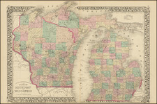
Early Antique Map of Iowa Territory and Wisconsin Territory
Scarce 1846 edition of Bradford's map of part of Iowa and Wisconsin, with large inset showing all of Iowa Territory and Wisconsin Territory extending to the Canadian Border.
Iowa Territory was organized in July 1838 and remained a Territory until 1846. Northern Iowa is primarily Indian Lands, with counties shown in the south. Wisconsin also has only a hand full of counties, all but Crawford being south of the Wisconsin River. The lands to the north include New York Indian lands. Massive Iowa and Brown Counties are shown. Many early forts, rapids, portages, etc., are shown. This is the first appearance of Iowa on a commercial atlas map, making this almost certainly its earliest appearance on any map.
Similarly, Wisconsin had only become a territory in July 1836, this being the first appearance in a commercial atlas. The inset tracks the drainage of the Missouri River to Canada and shows many Indian tribal lands, forts, etc. Bradford's Illustrated Atlas was first issued in 1838.
Thomas Gamaliel Bradford (1802-1887) was an American geographic publisher. He hailed from Bradford, Massachusetts and began his publishing career by working for the America Encyclopedia. Then, he edited and republished the Atlas Designed to Illustrate the Abridgement of Universal Geography, Modern & Ancient, which had originally been offered in French by Adrian Balbi. In 1835, he published another atlas, A Comprehensive Atlas: Geographical, Historical & Commercial, and, in 1838, An Illustrated Atlas Geographical, Statistical and Historical of the United States and Adjacent Countries. His interests were primarily in educational publishing and he was one of the first mapmakers to show Texas as an independent country.