This item has been sold, but you can enter your email address to be notified if another example becomes available.


|
||

|

|
|

|
Stock# 9141
Description
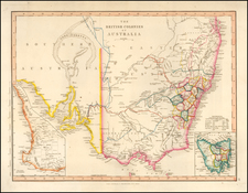
Large detailed map of Australia, showing bays, capes, creeks, islands, lakes, mountains, ports, rivers, shoals, towns, etc. The Colony of South Australia is separately shown. Populations for New South Wales, Van Dieman's Land, Port Phillip, South Australia, West Australia and North Australia are shown. Stuart's farthest north on Eyre's Creek is shown. The interior is quite unknown. An excellent early map of Australia.
![[Manuscript map of Terra Australis]](https://storage.googleapis.com/raremaps/img/small/92054.jpg)