


|
||

|

|
|

|
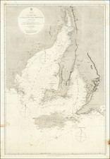
Detailed color-printed two-sheet geological map of New South Wales, published by the Department of Mines, Sydney, New South Wales, in 1914.
The map was prepared under the direction of E.F. Pittman, A.R.S.M., a government geologist.
The map contains a detailed key differentiating 25 different kinds of rock or other geological formations.
The map has an inset general overview of Australia in the lower-left corner titled: "Australia Showing positions of Lord Howe and Norfolk Islands"
This would appear to be an updated version of an 1893 geological map issued by the Department of Mines and Agriculture, also overseen by Pittman.
Pittman made numerous official geological maps in Australia throughout the end of the 19th and beginning of the 20th centuries.
![[ The Ptolemaic Universe ] Situs Terrae Circulis Coelestibus Circundatae . . .](https://storage.googleapis.com/raremaps/img/small/101512.jpg)