|
||

|

|
|

|
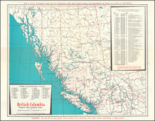
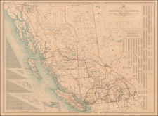
British Columbia Airports and Landing Strips, a mid-20th century map probably published in the 1960s, offers a detailed look at the airstrips of British Columbia, Canada. This map is an integral part of aviation history, serving as a testament to the burgeoning age of commercial air travel and the associated safety precautions of the era.
Published by Vacation Air and based on a list compiled by the British Aviation Council, this map provides a comprehensive layout of the airports and landing strips within British Columbia. It is emblematic of the growing importance of commercial and private aviation in post-WWII society and the rapid advancement of transportation infrastructure during this period. The map's candid cautionary message—"Do not fly to any fields listed without first checking with local control and filing a flight plan"—reveals the seriousness attached to air travel safety in those formative years of widespread commercial aviation.
Although not designed as a navigation map, the artifact carries significance as an aerial geographical reference that was used in conjunction with other aerial charts, the names and boundaries of which are indicated in red. This implies a system of layered cartographic references utilized in aviation during that time, underscoring the complexity and rigidity of mid-20th-century aerial navigation.
On the verso, the map hosts essays on air safety and the do's and don'ts of mountain flying. These texts provide valuable insights into the era's air safety protocols and mountain flying guidelines, making the map not just a geographical artifact but also an historical document on aviation safety. Overall, British Columbia Airports and Landing Strips stands as an engaging record of mid-20th-century aviation, encapsulating the era's geographic, technical, and safety-related narratives within its folds.
![[Collection of 10 manuscript charts and maps depicting the west coast of North America from Monterey, California, to just north of Salisbury Sound, Alaska.]](https://storage.googleapis.com/raremaps/img/small/98898.jpg)