


|
||

|

|
|

|
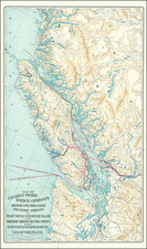
Fascinating scarce geological map of Vancouver Island and southwest British Columbia showing the stratigraphic layout of the area.
The map spans from Victoria in the south to Fitzhugh Sound in the north and shows the wild and mountainous region in detail.
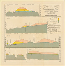
The map includes twelve stratigraphic formations ranging in age from Permian to modern times, although significant portions of the map are left uncolored as they have not yet been mapped. Roads, towns, and more are also shown, but the primary focus of the map is on mining developments. The locations of twenty different mineral occurrences are shown.
Most of the mining development shown occurs on Vancouver Island and in coastal or inlet areas, reflecting the inaccessibility of the Coast Mountains. Mapping also traces these areas, although some extensive mapping has been conducted inland in the northwest of the sheet, in the Chilko Lake area.
Mining and geological surveying had long been active in British Columbia, with coal mines opening first on Vancouver Island in the mid-1800s. The mountainous region still produces numerous heavy metals and other important minerals which were deposited due to the presence of significant hydrothermal flow from Cascadia volcanoes and the numerous and accreted igneous terranes.
In all, this is a fascinating and attractive geological map.
Rarity
The map is apparently rare on the market. We were unable to find another example offered for sale.
![[Run of 6 Volumes] Report Upon Geographical Surveys West of the 100th Meridian](https://storage.googleapis.com/raremaps/img/small/74064.jpg)
![[Important Early Geology Maps] Tableau du Climat et du Sol des Etats-Unis D'Amérique. Suivi d'éclaircissemens sur la Floride, sur la colonie Française au Scioto, sur quelques Canadiennes et sur les Sauvag . . .](https://storage.googleapis.com/raremaps/img/small/69358.jpg)
![[Vancouver] Fraser River and Burrard Inlet](https://storage.googleapis.com/raremaps/img/small/68029.jpg)