


|
||

|

|
|

|
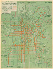
The "Official Route Map Los Angeles Transit Lines" serves as a comprehensive guide to the sprawling city of Los Angeles as it was in 1949. This map, produced by the LATL or the Los Angeles Transit Lines, offers a detailed view of the city's transit system, including coaches and streetcars, and encourages exploration of the city's vast 453.32 square miles.
Covering both the city and county of Los Angeles, the map provides valuable information about the population, estimated at 1,956,000 for the city and 3,880,000 for the county, with predictions for future growth. It highlights the extensive network of coach and rail routes, offering many different trip options. Special features include holiday service details, exceptions to regular schedules, and contact information for obtaining further details about schedules and points of interest.
The opening of the Arroyo Seco Parkway in 1940, linking Downtown Los Angeles and Pasadena with the first of what would be a network of freeways. Over the next decades, the car culture flourished in Los Angeles. America's automotive industry successfully conspired to emasculate LA's public transportation system, buying up and ending the street car bus and trolley service which had previously served LA and advocating the construction of auto-friendly roads. Within only a short time after this map, public transportation in LA would be nearly completely wiped off the map.
In the historical context, this map reflects the post-war boom of Los Angeles, a time when the city was rapidly expanding and public transportation played a vital role in connecting its diverse neighborhoods. The emphasis on seeing the city "by coach and streetcar" speaks to the era's sensibilities, promoting a "sensible, carefree way" to explore the "magic city of the West."
The map's design is both functional and inviting, encouraging residents and visitors alike to "take a tour of the town today." Overall, this map offers a vivid snapshot of Los Angeles at a specific moment in time, capturing the optimism and dynamism of a city on the move.
![Map of Los Angeles and Suburbs Copyrighted 1906 by A. Humitsch [Map of Los Angeles... Issued by the German-American Savings Bank]](https://storage.googleapis.com/raremaps/img/small/92785.jpg)
![(West Hollywood) Tract No. 2508. Spaulding Square, West Hollywood [bounded by Sunset Blvd in the north; Fountain Ave. in the south; Orange Grove in the west; and Spaulding in the east]](https://storage.googleapis.com/raremaps/img/small/97566.jpg)