


|
||

|

|
|

|
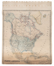
Surprisingly rare map of North America, published shortly after the publication of Lewis & Clark's map of their travels to the Pacific Ocean in 1814.
The lands acquired by the US in the Louisiana Purchase, extending to the Pacific, are clearly delineated, as is Spain's control of East and West Florida, the latter labeled as "Feliciana" (see below).
The map presents a remarkably informed picture of the hydographical featues in the Pacific Northwest, including a detailed treatment of the rivers on both sides of the Rocky Mountains. The Columbia River, Mult-no-may river and the Lewis River are shown, as is Mt. Rainder and the Nations of the Snake and Shoshone
Further South, California and the Great Basin are still largely unexplored and mythically shown, with the Rio San Felipe draining from Lakes Timpanagos and Teguayo to San Francisco Bay and a completely jumbled set of mountains shown east of the Coastal Range. In Southern California, a mythical River des Martyres flows parallel to the Colorado River.
The choice to show Nouvelle Albion in red, a small British region in Northern California, Oregon and Washington, is a very unsual addition for a French map.
Feliciana
Feliciana Parish, or New Feliciana, was a parish of the Territory of Orleans and the state of Louisiana, formed in 1810 from West Florida territory. It was divided in 1824 into East Feliciana Parish and West Feliciana Parish. Formerly part of the French La Louisiane, the area was settled largely by French colonists by about 1775, when it came under Spanish control during the American Revolutionary War. Feliciana is named for named by Marie Félicité St. Maxent, wife of the Spanish Governor Galvez.
Following the end of the American Revolution, the part of today's Louisiana which is east of the Mississippi River and north of Lake Pontchartrain was under Spanish Control until 1810. The area remained in controversy, even after the Louisiana Purchase. The West Florida section of what is now the state of Louisiana, was not included and terms of the Louisiana Purchase wers vague as to defining its eastern boundary. Though President Jefferson insisted that this area was American, Spain disagreed and continued their occupation.
Feliciana residents were generally not happy with Spanish rule and in 1810 established the short-lived Republic of West Florida. The Republic sought annexion with the Madison administration, and in October 1810, the area was declared to be part of the Louisiana Purchase and therefore the United States Territory.
Initially classified as "Feliciana County" and part of the Territory of Orleans, the a area was later subdivided into New Feliciana, East Baton Rouge, St. Helena, and St. Tammany. In 1812, when Louisiana was admitted to the Union, Feliciana Parish was included.

![[ First Map to Name The United States ] L'Amerique septentrionale ou se remarquent les Etats Unis . . . 1779](https://storage.googleapis.com/raremaps/img/small/94192.jpg)