|
||

|

|
|

|
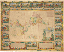
Unrecorded Early Christian Missionary Map of North America.
Interesting Idaho Configuration.
Impressive and unrecorded 19th-century wall map of North America published by the Society for Promoting Christian Knowledge.
The map can be pretty precisely dated to 1864 given the unusual configuration seen in the northern Rocky Mountains. Idaho sits beneath Washington and Montana, while Wyoming possesses a ledge in the Yellowstone region. This extremely ephemeral configuration existed on maps for a short period in 1864 following the creation of the Montana Territory, but the configuration with an Idaho panhandle was well-established by 1865.
A similarly early geopolitical configuration can be seen in Canada. Only Ontario and Quebec are clearly delimited as provinces on the mainland, with Labrador and British Columbia more nebulously delimited. New Westminster still appears in place of Vancouver.
History of the Society and the Society's Role in American Society
During the 18th century, SPCK played a pivotal role in expanding Christian education and missionary work, particularly in the British colonies. The society's influence reached North America, the Caribbean, and India, where they supported the establishment of schools and the distribution of religious literature. The aim was not only to spread Christian teachings but also to promote English cultural values. In the American colonies, SPCK's efforts were instrumental in the Anglicization process, aligning the religious practices with those of the Church of England. The society also fostered collaboration with other missionary organizations, creating a network that facilitated the spread of Anglican beliefs and practices.
The 19th century saw the continued growth and diversification of SPCK's activities. The society maintained its focus on education, but its reach extended beyond the colonies to encompass various parts of the British Isles. They were instrumental in the establishment of libraries, promoting literacy and making Christian literature accessible to a broader audience. The society also began to engage with emerging social issues of the time, such as poverty and industrialization, reflecting a broader understanding of the Christian mission. The 19th century marked a period of consolidation for SPCK, as it solidified its position as a leading force in promoting Christian knowledge, education, and social reform, adapting to the changing needs and challenges of the time.
During the 19th century, the Society for Promoting Christian Knowledge (SPCK) faced a changing landscape in America, particularly after the Revolutionary War, which led to the separation of the American colonies from British rule. The newly independent nation saw the establishment of the Episcopal Church as a distinct entity from the Church of England. SPCK's influence waned as the focus shifted from Anglicization to the development of an American religious identity. However, the society's legacy in education, literature distribution, and missionary work continued to be felt. The groundwork laid by SPCK in the previous century had a lasting impact on the Episcopal Church and the broader Christian community in America, influencing theological education and the availability of Christian literature.
Rarity
While we have been able to trace the existence of a 1920 edition of this edition of the map at the University of British Columbia, published by Stanford for the Society, we have been unable to locate any other example of this map through OCLC or related searches.
![[ First Map to Name The United States ] L'Amerique septentrionale ou se remarquent les Etats Unis . . . 1779](https://storage.googleapis.com/raremaps/img/small/94192.jpg)
![(North America) ПОЛИТИЧЕСКАЯ КАРТА СЕВЕРНОЙ АМЕРИКИ. [Political Map of North America]](https://storage.googleapis.com/raremaps/img/small/90261.jpg)