|
||

|

|
|

|
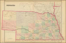
An excellent map of the region bounded by the Rockies in the west and the Sioux and Red River of the North on the east.
Colorado is showing the signs of its mining boom. Wyoming is limited to 4 counties, and is still largely unexplored in the north, as is Montana. Dakota has only one line of eastern Counties. Kansas and Nebraska still lack many western counties.
The map includes lots of Indian names and reservations, forts, rivers, mountains, railroads, explorers routes, etc.
Samuel Augustus Mitchell Jr. inherited the Mitchell Company from his father in 1860. For over thirty years, the company had specialized in the production of school atlases and wall maps of America. They were one of the pioneers on engraving on steel plates. In 1860, Samuel Jr. released the New General Atlas, which had been compiled in house and replaced a previous atlas by Tanner. The elder Mitchell died in 1868 and Samuel Jr. continued the business until the 1890s. At its height, the Mitchell Company employed 250 people and sold 400,000 publications annually.
![(Photograph album) America | Hawaii. 1885. [Photographic album of Hawaii, Yellowstone, Utah, Colorado, and Niagara Falls]](https://storage.googleapis.com/raremaps/img/small/87949.jpg)