|
||

|

|
|

|
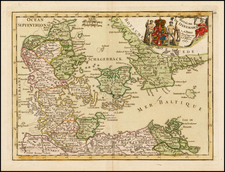
Detailed regional map of the southern tip of Norway, inlcuding the cities of Bergen and Stavanger.
The map shows the region in fine detail, with fjords, mountains, rivers, towns, and cities shown. In the lower left is a decorative, French-style cartouche. A scale bar is provided in the upper left.
Regional maps of Norway from this period showing inland detail as this region was not as much of a focus for the cartographers of western Europe who specialized in making maps of their home regions or of areas where trade was occurring. Sanson executed perhaps the best widely-circulated (but still very rare) suite of maps of Norwegian regions from the time. Along with this map, Sanson also issued the first printed map of all of Norway
Nicholas Sanson (1600-1667) is considered the father of French cartography in its golden age from the mid-seventeenth century to the mid-eighteenth. Over the course of his career he produced over 300 maps; they are known for their clean style and extensive research. Sanson was largely responsible for beginning the shift of cartographic production and excellence from Amsterdam to Paris in the later-seventeenth century.
Sanson was born in Abbeville in Picardy. He made his first map at age twenty, a wall map of ancient Gaul. Upon moving to Paris, he gained the attention of Cardinal Richelieu, who made an introduction of Sanson to King Louis XIII. This led to Sanson's tutoring of the king and the granting of the title ingenieur-geographe du roi.
His success can be chalked up to his geographic and research skills, but also to his partnership with Pierre Mariette. Early in his career, Sanson worked primarily with the publisher Melchior Tavernier. Mariette purchased Tavernier’s business in 1644. Sanson worked with Mariette until 1657, when the latter died. Mariette’s son, also Pierre, helped to publish the Cartes générales de toutes les parties du monde (1658), Sanson' atlas and the first French world atlas.
![[ Scandinavia ] Tabula Geographica Regnorum Sueciae Daniae et Norwegiae](https://storage.googleapis.com/raremaps/img/small/102797.jpg)