|
||

|

|
|

|
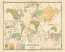
Fine and extremely detailed pre-World War II map of the world, focusing on the land and sea connections between the countries of the world.
The map offers a wealth of information and includes many toponyms that are uncommon to see on world maps, particularly in the arctic regions. Currents are shown and named, as are major shipping and railroad networks. The map balances providing extensive human and physical geography.
The map shows pre-World War II boundaries. In Europe, the Danzig corridor that splits Germany from Prussia remains. In East Asia, Japan has control of half of Sakhalin, as well as Taiwan, and Korea. Much of the world is shaded pink to represent Great Britain's various claims. British Antarctica is shown.
The map includes four insets, showing the Panama Canal, Alaska, the Eastern Pacific Islands, and the Suez Canal. The map was published in Great Britain by George Philip and Son.
![[ Map Game Board ] Wallis's New Game, exhibiting a Voyage round the World.](https://storage.googleapis.com/raremaps/img/small/98593.jpg)
![[Wall Map] Orbis Terrarum Nova et Accurata Tabula. Auct. G. Valck.](https://storage.googleapis.com/raremaps/img/small/41630dc.jpg)