


|
||

|

|
|

|
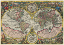
Finely colored example of the first state of Danckerts' richly embellished map of the World, based upon De Wit's world map of 1668.
The geographical details include California as an Island, incomplete coastlines for Australia and New Zealand and no trace of the Antarctic. There is no coastline north of California, nor is the land bridge to Asia present. The Great Lakes are shown with open ends to the west.
The map is embellished by four large lively allegorical scenes, representing the four elements. Fire is shown by war and destruction, air by the heavens, earth by harvesting and husbandry and water by ships and a spouting whale. There are groups of figures between the hemispheres and on either side of the smaller polar maps.
Justus Danckets began his career as a mapmaker in Amsterdam in the 1670s. His atlases are rarely dated, so the 1680 dating based upon the early appearances of his work. A proof or unfinished example of this map is found in the British Library, with portions of the allegorical scenes left incomplete and is believed to date from the 1660s, meaning that it is possible this map appeared earlier as well.
The first state follows De Wit's map of 1668, while the later state of the map includes a mythical coastline from California to Asia and has significant additional land masses added in the two polar projections, among other changes.
The popular misconception of California as an island can be found on European maps from the sixteenth through the eighteenth centuries. From its first portrayal on a printed map by Diego Gutiérrez, in 1562, California was shown as part of North America by mapmakers, including Gerardus Mercator and Abraham Ortelius. In the 1620s, however, it began to appear as an island in several sources. While most of these show the equivalent of the modern state of California separated from the continent, others, like a manuscript chart by Joao Teixeira Albernaz I (ca. 1632) now in the collection of the National Library of Brasil shows the entire western half of North Americas as an island.
The myth of California as an island was most likely the result of the travel account of Sebastian Vizcaino, who had been sent north up the shore of California in 1602. A Carmelite friar, Fray Antonio de la Ascensión, accompanied him. Ascension described the land as an island and around 1620 sketched maps to that effect. Normally, this information would have been reviewed and locked in the Spanish repository, the Casa de la Contratación. However, the manuscript maps were intercepted in the Atlantic by the Dutch, who took them to Amsterdam where they began to circulate. Ascensión also published descriptions of the insular geography in Juan Torquemada’s Monarquia Indiana (1613) (with the island details curtailed somewhat) and in his own Relación breve of ca. 1620.
The first known maps to show California as an island were on the title pages of Antonio de Herrera’s Descripción de las Indias Occidentales (1622) and Jacob le Maire's Spieghel Der Australische Navigatie (1622). Two early examples of larger maps are those by Abraham Goos (1624) and another by Henry Briggs, which was included in Samuel Purchas’ Hakluytus Posthumus or Purchas his Pilgrimes (1625). In addition to Briggs and Goos, prominent practitioners like Jan Jansson and Nicolas Sanson adopted the new island and the practice became commonplace. John Speed’s map (1626-7), based on Briggs’ work, is well known for being one of the first to depict an insular California.
The island of California became a fixture on mid- and late-seventeenth century maps. The island suggested possible links to the Northwest Passage, with rivers in the North American interior supposedly connecting to the sea between California and the mainland. Furthermore, Francis Drake had landed in northern California on his circumnavigation (1577-80) and an insular California suggested that Spanish power in the area could be questioned.
Not everyone was convinced, however. Father Eusebio Kino, after extensive travels in what is now California, Arizona, and northern Mexico concluded that the island was actually a peninsula and published a map refuting the claim (Paris, 1705). Another skeptic was Guillaume De L’Isle. In 1700, De L’Isle discussed “whether California is an Island or a part of the continent” with J. D. Cassini; the letter was published in 1715. After reviewing all the literature available to him in Paris, De L’Isle concluded that the evidence supporting an insular California was not trustworthy. He also cited more recent explorations by the Jesuits (including Kino) that disproved the island theory. Later, in his map of 1722 (Carte d’Amerique dressee pour l’usage du Roy), De L’Isle would abandon the island theory entirely.
Despite Kino’s and De L’Isle’s work, California as an island remained common on maps until the mid-eighteenth century. De L’Isle’s son-in-law, Philippe Buache, for example, remained an adherent of the island depiction for some time. Another believer was Herman Moll, who reported that California was unequivocally an island, for he had had sailors in his offices that claimed to have circumnavigated it. In the face of such skepticism, the King of Spain, Ferdinand VII, had to issue a decree in 1747 proclaiming California to be a peninsula connected to North America; the geographic chimera, no matter how appealing, was not to be suffered any longer, although a few final maps were printed with the lingering island.
The Danckerts were a family of Dutch engravers and geographers who produced geographic materials, including a series of original atlases. Initially, Justus I Danckerts (1635-1701) was a book and print publisher based in Amsterdam. His great-uncle, Cornelis Danckerts de Rij, (1561-1634) was a surveyor who produced a Kaert-boeck showing various views of Amsterdam. His brother, Dancker Danckerts (1634-1666), was a skilled engraver who produced several maps. Justus I was most likely influenced by both their work when he followed his father, Cornelis I Danckerts (1603-1656), into the publishing business.
In the early 1680s, Justus decided to embark upon a new project, an atlas with all the maps made in house. Such a project was feasible because two of his sons with his wife, Elisabeth Vorsterman, Theodorus I (ca. 1663-ca. 1720) and Cornelis II (1664-1717) had recently come of age and were trained in engraving and etching. Justus’ decision was most likely influenced by his surroundings; Amsterdam was the center of map publishing in the seventeenth century and in the 1680s several local publishers sought to join the atlas market then dominated by the Blaeu and the Hondius-Janssonius atlases.
Together, the brothers created their first maps in the mid-1680s. In 1684, the family received a 15-year privilege to protect their maps and they were then publishing both folios sized maps, the basis of an atlas, and wall maps for sale. Their first atlases contained around 20 original maps and 4-5 maps by other cartographers like Visscher and De Wit. The first known atlas to contain only Danckert maps was a 26-sheet volume published in 1690. As a guide, the Danckerts turned to similar atlases by De Wit, but by 1690 they clearly had the knowledge and capacity to produce their own original work.
After the first 26-sheet atlas, the Danckerts released a 37-sheet (1692-4), a 50-sheet (1694-6), and a 60-sheet (1698-1700) atlas. Several of the maps added to the atlases in the 1690s reflect the theater of the Great Alliance War (1688-1697). Other political events also influenced the contents of the atlases. For example, the English and Irish sheet maps were altered in 1688-9 and 1689-91 respectively, just after the Glorious Revolution of 1688.
In 1692, Justus II (?-1692), a third son of Justus I, died. A series of maps bearing a distinct style which abruptly stopped at this time have been attributed to him. A family member assumed to be another son of Justus I, Eduard (?-after 1721) came of age around the same time. Analysis of engraving style suggests that Eduard was heavily involved in the engraving process, working alongside Theodorus I and with another relation, also presumed to be a younger son of Justus I, Johannes (?-1712), thereafter.
Justus I drew up his will in 1696 and most likely retired from daily management of the shop at this time, although he lived until 1701. The aforementioned Johannes, who had a distinct engraving style, began contributing to the map engraving in 1700, although most of the maps he worked on are published under the name of another brother. The privilege had expired in 1699 and its renewal in the same year, before the death of Justus I, could explain why his sons continued to publish in his name after his death. Using the well-known name of Justus could protect the younger sons whose own reputation was not yet established.
In the new century, many of the maps were reworked or completely redone, as was the case with the world map and those of the continents. New maps were added to reflect the new areas of fighting in the War of the Spanish Succession, including new depictions of Italian states, the southern Netherlands, and the German provinces. In 1706, Albert Schut joined the business as an engraver and etcher and his name appears on maps from then onward. Between 1700 and 1712, the number of atlas maps increased to 75 and then 100 sheets. It seems Cornelis II was the main voice in atlas contents during this time, while Theodorus I’s role is unclear.
Johannes died in 1712, radically changing the business’ daily routine. Johannes had not only been an engraver, but also the firm’s representation to the Frankfurt Book Fair, the largest book fair in Europe at that time. As the German market was the main source of income for the Danckerts, his death was a heavy blow.
Over the next two decades, the pace of new map production slowed drastically. Only two known maps made during this period are known today: a third world map, engraved by Jacob Folkema, and a Hispania map published with Cornelis II’s name. Neither of these featured in the atlases. After 1717, when his father Cornelis II died, a few maps were reworked by Theodorus II and the contents of the atlases were altered slightly to include those printed from unfinished plates.
By 1726, Theodorus II was in debt. He gave much of his stock to a creditor, T. Rijswick, just before he died in 1727. The stock was sold at auction by Rijswick and other publishers, including the Ottens and Van Keulen, bought plates from the atlas.
Lack of biographical data is a problem for all the Danckerts, especially the younger brothers. Justus I was born in Amsterdam, where he also began his business. All the sons were born and presumably died there. Justus II’s death date is all that has survived of him in the records, and all that is known of Eduard is that in 1721 he served as uncle and guardian to Theodorus II (ca. 1701-1727), the son of Cornelis II. After that nothing is known of him. Theodorus I most likely died between 1718 and 1721. He had a son, Gerit (ca. 1708-after 1731), but the lad does seem to have become a map engraver. With the death of Theodorus II, therefore, there were no more Danckerts to carry on the business even if Theodorus II had avoided debt.
Although not as long-lived as some of the other family firms, for the decades surrounding the turn of the seventeenth-century the Danckert family produced well-respected and widely distributed wall maps and atlases. They joined the atlas trade at a time when atlases were increasing in popularity and the expansion in the number of sheets included in their atlases indicate both their popularity and the skill of the engraving brothers.
![Historiarum Indicarum Libri XVI [with:] Indiarum Orientalium Occidentaliumque Descriptio. Pet. Maffei Historiae Harum Verissimae, Dedicata.](https://storage.googleapis.com/raremaps/img/small/102793.jpg)
![Apollo Earth Orbit Chart (AEO) Apollo Mission 8. Sheet 1 of 3, Contains Revolution 1. For December 1968 Launch Dates [with:] Sheet 2 of 3, Contains Revolution 2. For December 1968 Launch Dates [and: Sheet 3 of 3, Contains Revolution 3. For December 1968 Launch Dates]](https://storage.googleapis.com/raremaps/img/small/95707.jpg)