|
||

|

|
|

|
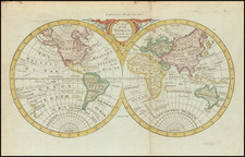
The World As Known In Greek Classical Times
Rare mid 19th Century world map illustrating the geographic understanding of the ancient Greeks, specifically highlighting the world according to Hesiod, Homer, and Orpheus.
The main map is a circular hemispherical projection centered on the Mediterranean, encapsulating regions known and mythologized by the ancient Greeks. It is color-coded, with the area believed to be Europe marked in a pink hue, Asia in a lighter shade, and Libya (Africa) in a pale blue, reflecting the three-partite division of the world in classical geography.
In addition to real geographic locations, the map includes mythical places such as the "Garden of the Hesperides," "Cimmerians," and the "Hyperboreans." It also marks the supposed routes of the Argonauts in their quest for the Golden Fleece and the extensive wanderings of Odysseus as narrated in Homer's Odyssey.
In the lower corners of the map are two inset maps. The one on the left illustrates the "System of Democritus," showing a pre-Socratic conception of the world, with a landmass that merges Europe and Asia and a large southern continent labeled 'Libya.' On the right is the "System of Scylla and Charybdis," detailing the narrow straits between Sicily and mainland Italy, which were notorious hazards for ancient mariners and were mythologized in the Odyssey.
Overall, the map serves as an educational tool, merging the geographical knowledge of ancient civilizations with the mythical narratives that have shaped much of Western literature and culture. It is both a cartographic creation and a window into the mindset and worldview of the ancients as interpreted by the scholars of the late 19th century.
![Planisphere Physique ou l'on voit du Pole Septentrional ce que l'on connoit de Terres et de Mers Avec les Grandges Chaines de Montagnes . . . [Bay or Sea of the West]](https://storage.googleapis.com/raremaps/img/small/98378.jpg)