|
||

|

|
|

|
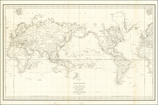
Interesting double hemisphere map of the world from Brooke's Gazetteer, a popular geographical work published in London in the late 18th Century.
A notable feature of this antique map is the emphasis on the discoveries made during Captain James Cook's first two voyages. Cook, an eminent British explorer, embarked on several expeditions during the late 18th century, contributing significantly to the expansion of geographical knowledge. The map proudly highlights the routes and discoveries from these voyages, including Cook's exploration of the Pacific Ocean, the coastlines of Australia, New Zealand, and hints of Antarctica.
It is worth noting that this particular antique map does not include the discoveries from Cook's third voyage. As the map predates his final expedition, it provides a glimpse into the state of geographical knowledge at that specific historical juncture, capturing a moment in time before further explorations and advancements were made.
![(World - First State!) Benedict Arias Montanus Sacrae Geographiae Tabulam ex Antiquissimorum Cultor. [Pre-Dutch Discovery Depiction of Australia]](https://storage.googleapis.com/raremaps/img/small/93232.jpg)
![[ Volcanic Regions ] Geografia Dei Vulcani Accesi Ed Estinti](https://storage.googleapis.com/raremaps/img/small/101861.jpg)