|
||

|

|
|

|
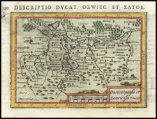
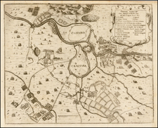
Fine example of Gerard de Jode's map of northern Germany and western Poland, naming many cities and towns throughout the region.
Gerard de Jode's map of Saxonum Regionis is notable for its intricate geographical detail. With impressive precision, it delineates the territories of what would now encompass parts of Germany, Denmark, and western Poland. Notably, the map represents the extent of the Saxon Empire, a significant historical state of early medieval Europe.
The map stands out not just for its geographical accuracy but also for its artistic flourishes. The North Sea is enlivened by the presence of a sea monster, a common embellishment in maps of the period that speaks to the period's mixture of scientific curiosity and imaginative speculation. On the Baltic Sea, a sailing ship is depicted, reflecting the region's maritime culture and the importance of seafaring for trade, exploration, and warfare.
The map's engraver, Johannes van Deutecum, lends his artistic touch to the map's design. The map is drawn from the work of Christian Sgrothen (also known as Christianus Schrot), a significant cartographer of the 16th century (see below).
The geopolitics of the Saxon region during the second half of the 16th century was complex and dynamic. This was a period marked by the growing power of centralized monarchies, the struggle between Protestantism and Catholicism, and the ongoing conflict between the Habsburg Empire and its rivals. The Saxon region, part of the broader Holy Roman Empire, was characterized by a complex patchwork of duchies, bishoprics, free cities, and other types of territories. The map, therefore, serves as a visual representation of this political fragmentation.
Christian Sgrothen
Christian Sgrothen (1525 - 1603) is regarded as a significant cartographer of the 16th century, comparable to Gerhard Mercator.
Sgrothen worked as a painter and cartographer in Kalkar on the Lower Rhine, where he became a citizen in 1548 and purchased a house on the market square in 1553. Around 1555, Sgrothen started the first mapping of the Lower Rhine region. On December 2, 1557, he began serving the Spanish King Philip II as a court cartographer ("Geographus Regiae Maiestatis Hispaniae").
The government in Brussels initially assigned him to map the Dutch provinces and surrounding regions, a task for which Sgrothen traveled throughout the entire Lower German region. In 1568, Sgrothen started his major work, the mapping of the Holy Roman Empire, completed in two versions in 1572/73 and 1592 but never published. He died in Kalkar in 1603 and was buried in the church of the Dominican monastery.
Sgrothen's work represents the most crucial mapping of the Lower Rhine in the 16th century and was the foundation for Mercator's maps of the region. In 1558, a map of the Duchy of Guelders and the County of Zutphen was published in Antwerp, followed by a map of the Duchy of Geldern in 1564, a map of Germany in 1565, and a map of the Holy Land in 1570. His works also include a photograph of the fortifications of Amsterdam (1566).
Sgrothen's primary work took 25 years to complete. He was the first to systematically map the territory of the Holy Roman Empire commissioned by royalty. The first version, known as the "Brussels Atlas" from 1572/73, includes 38 maps of Central Europe in the format 66 × 64 cm, while the second version from 1592, the "Madrid Atlas", contains 33 maps of Europe and several world and Orient maps in the format 83 × 64 cm. They cover the area between Denmark and the Adriatic Sea and between Flanders and Poland, with a focus on the northern German states. These atlases are considered among the most beautiful maps of the Renaissance era, and their names reflect their current locations.
The present example is from the first edition of De Jode's work, which can be distinguished from the second edition by the pagination on the verso (it is paginated using Roman numerals rather than Arabic). The map first appeared in the rare first edition (of two) of De Jode's Speculum Orbis Terrarum. At least one commentator has opined that as few as 11 known complete examples of the first edition are known to have survived, making separate maps from this first edition very rare on the market.
De Jode's Speculum Orbis Terrarum
One of the great rarities of sixteenth-century mapmaking, the De Jode family's Speculum Orbis Terrarum represents over twenty-five years of work shared between two generations. The work was published in two editions, first by Gerard de Jode in 1578 and then in an expanded edition by his son, Cornelis, in 1593.
The Speculum is the second general atlas of the world, after Ortelius' Theatrum Orbis Terrarum. In Antwerp, in 1570, Ortelius published the first modern atlas; that is, a set of uniform maps with supporting text gathered in book form. Previously, there were other bound map collections, specifically, the Italian Lafreri atlases, but these were sets of maps—not necessarily uniform—selected and bound together on demand.
The first edition of Gerard De Jode’s atlas was published in Antwerp in 1578. Gerard De Jode (1509-1591) released his atlas in a golden age of Dutch atlas production: Ortelius’ atlas was released in 1570, also in Antwerp; the first town atlas was in 1572, the first pocket atlas in 1577, the first regional atlas in 1579, the first nautical atlas in 1584, and the first historical atlas in 1595. De Jode’s atlas was intended as competition for Ortelius’. Mercator was also preparing an atlas at the time, and corresponded with Ortelius, but it would not appear in full until 1595, a year after Mercator’s death.
Although the Speculum was ready as early as 1573, it was not published until 1578. This is most likely due to Ortelius’ influence and his privilege over atlas production, which expired just before De Jode finally published. The atlas was the result of collaboration between De Jode, the geographer Jan van Schille of Antwerp, German physician Daniel Cellarius, and the etchers Joannes and Lucas van Doetecum.
Although never as successful as Ortelius’ Theatrum, the Speculum did get republished in a second edition in 1593, two years after De Jode’s death, by Arnold Coninx. After his death, Gerard’s son, Cornelis (1568-1600), and his wife, Paschina, then ran the shop. Unfortunately, Cornelis died young in 1600, aged only 32, and the stock and plates were sold to the publisher Joan Baptista Vrients. Vrients had also recently purchased the plates for Theatrum, giving him a monopoly over Antwerp atlas publication. Vrients acquired the De Jode atlas plates only to suppress them in favor of the Ortelius plates, thus the De Jode atlas maps are quite rare on the market today.
Scholarly and historical comparison between the Speculum and the Theatrum varies. The great cartographers of the late sixteenth- and early seveneenth-centuries, including Montanus, van den Keere, and von Aitzing, used both as sources, and Hondius compared the former work favorably against the latter. Later scholarly review notes less consistency in the cartography in de Jode's work, particularly in some of the Germanic regions, although the craftsmanship of the engraving is highly praised.
Gerard De Jode (1509-1591) was a pre-eminent mapmaker in the late seventeenth century, a time when the Dutch dominated the map trade. He was known for his many maps, some of which featured in Speculum Orbis Terrae (first edition Antwerp: 1578). Although never as successful as Ortelius’ Theatrum, the Speculum did get republished in a second edition in 1593, two years after De Jode’s death, by Arnold Coninx, and included this map. After his death, Gerard’s son, Cornelis (1568-1600), and his wife, Paschina, ran the shop. Unfortunately, Cornelis died young in 1600, aged only 32, and the stock and plates were sold to the publisher Joan Baptista Vrients.
![(Second World War - Prelude to War) Die Luftbedrohung Deutschlands [The Air Threat to Germany]](https://storage.googleapis.com/raremaps/img/small/84075.jpg)