


|
||

|

|
|

|
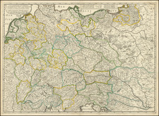
Interesting post-World War II British occupation of Germany map representing the infrastructure and administrative divisions within northwest Germany.
The region shown covers an area from Cologne (Koln) in the south to the border with Denmark in the north, including significant cities such as Hannover and Hamburg. The majority of the area depicted falls within the British Zone of Occupation, with a smaller section labeled "U.S. Enclave," indicating an area administered by the United States. The I.A. & C. Division refers to the Information and Civil Division, a British administrative body responsible for overseeing various aspects of civilian life in post-war Germany under British control.
The map features a legend that provides detailed information about various types of transportation infrastructure, including railways, roads, and waterways. Railways are differentiated by the number of tracks, gauges, and other features such as electrified lines, tunnels, and stations. Roads are categorized by types such as independent motor highways, main roads, and other main roads, with information about their width and construction. Waterways are classified by the carrying capacity of the navigable craft, providing insight into the region's trade and transportation capabilities.
In addition to transportation infrastructure, the map shows administrative boundaries such as the British Zone boundary, Corps District boundary, and Provinz (province) boundary. Surrounding the map are boxes labeled "Education Branch," "Public Safety Branch," "Administration and Local Government Branch," "Survey Branch," "Entries & Exits Branch," "Health Branch," and "Posts & Telecommunications Branch." These boxes communicate information about the various administrative departments responsible for managing and overseeing different aspects of civilian life within the occupied region.
The purpose of this map is multi-fold. Firstly, it serves as a geographical representation of the British zone, delineating its boundaries and internal administrative divisions such as the Corps and Provinz boundaries. It also includes a legend that describes the different types of railways and roads, emphasizing the transportation infrastructure that was likely crucial for post-war reconstruction efforts and the movement of military and civilian personnel.
The map goes beyond mere geographical information by including tables and texts that describe the situation on the ground as of mid-January and late February 1946. These sections are divided into several branches: Education, Public Safety, Administration and Local Government, Survey, Health, Posts & Telecommunications, Entries & Exits, and a legend explaining the symbols used on the map.
From the Education branch data, we can ascertain the state of schools, the number of students, and the status of educational infrastructure, reflecting the efforts to restore normalcy in civilian life. The Public Safety branch gives insights into police training, uniform policies, crime rates, and black market activities, indicating the challenges of maintaining law and order during the occupation.
The Administration and Local Government branch includes details on democratization, administrative directives, war graves, and political activities, showing the administrative reorganization and the revival of local governance. The Survey branch notes the completion of information collection regarding administrative boundaries, a task vital for governance and planning.
Health-related statistics are presented, including hospital beds, birth and death rates, and figures on displaced persons (DPs) and prisoners of war (POWs), highlighting the public health concerns and the human impact of the war. The Posts & Telecommunications branch reveals the status of postal services, telephone lines, and radio, essential for communication within the zone and with the outside world.
Travel statistics indicate the permits issued and clearances granted, painting a picture of the movement of people in a tightly regulated environment. Lastly, the legend provides an understanding of the transportation networks critical for the distribution of goods and the movement of people and troops.
Rarity
The map is apparently very rare. We were unable to find another example.
Acquired as part of a group of 3, each with different dates.
![[ Postal Map of Eastern Europe ] Deutschlands Postkarte begraenzt von Oesterrreich, Preussen, Frankreich, Holland, Italien und der Schweiz. Gezeichnet und Herausgegeben von Ignaz Heymann. K.K. Obserpostamtsoffizier in Trieste. 1800.](https://storage.googleapis.com/raremaps/img/small/77678.jpg)
![(World War II - Jewish Resistance in Poland) ספר מלחמות הגיטאת [Book of the Ghetto Wars]](https://storage.googleapis.com/raremaps/img/small/81013.jpg)