|
||

|

|
|

|
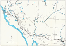
Russian America Following the Treaty of St. Petersburg - Large Inset of Russian California
Rare Russian America, published at the height of Russian influence on the West Coast of North America.
This important map, published in St. Petersburg in 1826, depicts Russian America at a point in time where the geo-political future of the Northwest Coast was still very much undecided. It is one of the first maps to show Russian Alaska's newly defined boundaries with British North America, as defined by the Treaty of St. Petersburg (1825). As shown on the map, the Russians were given the coastline as far down as 54"40', whereupon their territory hugged the coast up to the 141st meridian West, and thereafter due north to the Arctic. Ambiguities in this treaty ensured that portions of this boundary remain in dispute between the U.S. and Canada even up to the present day.
Streeter noted:
The boundaries of the Russian territory in North America are delineated, with an interesting inset of California from 35°N to 40°N showing the Russian establishment there. The slight extent to which the Seward peninsula had been explored to this time is demonstrated by the extension of Golovin Sound northeast from Norton’s Bay to the ocean north of Bering Strait, so that the area of the present Nome is shown as being on a large island.---TWS.
Piadychev based the map on a variety of Russian and British sources, The map depicts the coastal areas of southern Alaska and adjacent regions, including the Aleutians, with considerable accuracy, as well as the shores of the Bering Strait, on both the American and Asian sides. Various Russian forts are noted, ranging from Sitka (founded 1806), the capital of Russian America to Petropavlovsk in Kamchatka. Conspicuously, almost all of the interior and the Northern Slope of Alaska, remains a complete enigma, having not yet been explored, let alone mapped.
Interestingly, the large inset embraces the coastline of California, extending from Cape Mendocino down as far as Santa Barbara. This encapsulates the contemporary Russian ambitions in California, which were centered at Fort Ross (located in modern Mendocino County), which the Russian American Company maintained between 1812 and 1841. The present map was made not long after the expedition of Otto von Kotzebue (1815-8), visited both California and Alaska, strengthening Russian's territorial claims.
The map exhibits some of the most significant progress along the Northernmost coastline of Alaska, where the progress in mapping the coastline is perhaps most profound. There have clearly been significant improvements in the understanding of the coastline from the time of Wilbrecht's monumental map of 1802, as shown here: /gallery/detail/24404
The map was later included in Vasilii Petrovich Piadychev's atlas of the Russian Empire, Geograficeskij Atlas Rossijskoj Imperii, carstva Poljskago i velikago knjazestva Finlandskago raspolozennyi po gubernijam na dvuch jazykach s oznaceniem v onych gorodov, mesterek, sel Pjadysevym 1823 goda. - Atlas géographique de l'Empire de Russie, du Royaume de Pologne et du Grand Duché de Finlande. . ., published in 1828, which featured maps issued between 1823 and 1827. In order to appeal to an audience beyond Russia, the map is jointly inscribed in French. The title of the present map, transliterated title in Russian, is " General'naâ karta Cukotskoj zemli, Aleutskih" ostrovov" i severo-zapadnago berega Ameriki socinena po novejsim" svedenìâm".
Rarity
The map is extremely rare on the market. The last example to appear at auction was the Streeter copy (1969), acquired from Henry Stevens in 1941. There are no records of the map listed in dealer catalogs in AMPR.
A second edition of the map was issued with the date of 1829, which is also extremely rare on the market.
Piadyshev was the cartographer at the Military-Topographical Depot of His Imperial Majesty's General Staff, during the production of the first systematic survey or Russia, with maps published between 1820 and 1827.
Piadyshev's Geograficheskii atlas Rossiiskoi imperii, tsarstva Pol'skogo i velikogo kniazhestva Finliandskogo (Geographical Atlas of the Russian Empire, the Kingdom of Poland, and the Grand Duchy of Finland . . . ) was the first atlas of its kind - both comprehensive and accurate - depicting an empire that stretched from the Vistula River to the Pacific Ocean. It is credited to Col. Vasilii Petrovich Piadyshev (1768-1835), who served with distinction in the Military-Topographical Depot of His Majesty's General Staff. The sheets were published between 1820 and 1827; the work underwent revision in 1828-1829 and was reprinted in 1834. The atlas is composed of 60 maps, including a general map of the empire.
Curiously, the atlas is not constructed on a consistent scale and does not use the same projection on all maps. Each sheet describes administrative boundaries, rivers, roads, urban and rural settlements, and a variety of other details. Distances are in versts (1 verst = 1.07 kilometer). On each sheet, placenames are rendered in Russian and in French transliteration.
The atlas reflects the detailed mapping carried out by Russian military cartographers in the first quarter of the 19th century. The map shows population centers (five gradations by size), fortresses, redoubts, roads (four types), provincial and district borders, plants, and factories. Distances are shown in versts, a Russian measure, now no longer used, equal to 1.07 kilometers. Legends and place-names are in Russian and French.
The atlas underwent revision in 1828-1829, and was reprinted in 1834.
![(Russian Adventurism in China) Карта Средней Азии Составлена К. Веберомъ... 1871. [Map of Central Asia Compiled by K. Weber... 1871.]](https://storage.googleapis.com/raremaps/img/small/58597.jpg)