


|
||

|

|
|

|
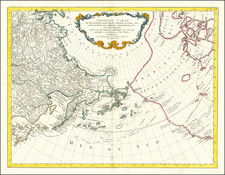
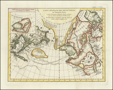
Rare separately published Russian map of the North Pacific and coastlines of Northwestern America and Northeastern Asia, synthesizing the best available information from Russian and European explorers, including Cook, La Perouse and Vancouver.
The title translates as follows:
Map of the Marine Discoveries of Russian Navigators in the Pacific and the icy seas, accomplished in various years. Compiled at His Imperial Majesty's depot of charts, corrected by the latest observations of foreign navigators, and engraved in the year 1802.
The exact title in Russian (as listed by the Library of Congress Map Division) is
Karta morskikh otkryt?i Ros?iskimi moreplavateliami na Tikhom i Ledovitom moriakh : v raznykh godakh uchinennykh / pri sobstvennom Ego Imperatorskago Velichestva Depo kart sochinena i po novieishim nabliuden?iam inostrannykh morekhodtsov vypravlena i gravirovana 1802go goda ; soch. A. Vilbrekht.
The map extends from Alaska, Vancouver and the Washington-Oregon Coastline to Japan and the NW Coast of the Russian Empire, on the eve of Russia's final push to explore and map the Northwest Coast of America. Among other features, the map includes a detailed treatment of the volcanoes in Kamchatka and the Aleution islands. The map provides excellent detail in Alaska and along the Northwest Coast of America, reaching as far south as the Northernmost part of California, a foreshadowing of the Russian attempts at colonization along the California Coast.
Wilbrecht's large and accomplished chart was the most accurate of the region at the time of publication, being the first to combine the discoveries of Cook with those of the Russians. The chart covers the north Pacific Ocean, a small part of the Arctic Ocean north of Bering Strait, and the adjacent coastal regions of Russia and the American coastline from the 40th parallel (northern California), The map is not signed, but it has been ascribed to Wilbrecht, who published an earlier atlas of Russia - Rossiiskoi Atlas - in 1792 and an earlier chart of the Pacific in 1787, which appeared in his atlas (see below).
Evidence of the high regard in which this map is held is that it was cited by both the American and British side in the Alaska Boundary Tribunal of 1903. A fragment of the map is included as map 6 in United States atlas: maps and charts accompanying the Case and Counter Case of the United States, by the Alaskan Boundary Tribunal, and published by the United States Government Printing Office, Washington, D.C., 1904.
Alexander Wilbrecht (1757-1823) was a mathematician , geographer , cartographer and astronomer . Wilbrecht served as Geographer of The Geographic Department of the Cabinet of Her Imperial Majesty. In 1782, he produced the first Russian atlas . He also produced a number of important separately isued. maps between 1787 and 1802. Wilbrecht is credited with authorship of several atlases, including Ross'iiskoi Atlas iz soroka chetyrekh kart sostaiashch'ii I na sorok na dva namiestnichestva Imper'iiu razdieliaushch'ii. [The New Atlas or a Collection of all parts of the Globe], St. Petersburg, 1793 (Philips 679).
The map is of the utmost rarity. We are aware of only the example held by the Library of Congress and this example, which was previously offered for sale in 2004 (Martayan Lan Catalog 34, Item 54 (our copy)).
![(Germans in California) [Manuscript journal kept by Pastor J. K. Nagel recording names and details of German residents of Santa Rosa, Visalia, Fresno; Sonoma and Tulare Counties; San Joaquin Valley] Diarium Pastorale. Hilfs-und Schreibbuch für Geistliche](https://storage.googleapis.com/raremaps/img/small/97633.jpg)
![[French & Indian War] Carte Des Possessions Francoises et Angloises dans le Canada et Partie de la Louisiane . . . 1756](https://storage.googleapis.com/raremaps/img/small/94026.jpg)